
 Français
 Italiano
Size of this PNG preview of this SVG file: 440 × 599 pixels. Other resolutions: 176 × 240 pixels | 352 × 480 pixels | 564 × 768 pixels | 752 × 1,024 pixels | 1,504 × 2,048 pixels | 489 × 666 pixels.
Original file (SVG file, nominally 489 × 666 pixels, file size: 141 KB)
This is a file from the Wikimedia Commons and may be used by other projects. Information from its description page there is shown below. Commons is a freely licensed media file repository. |
Summary
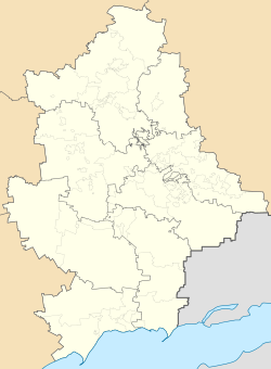
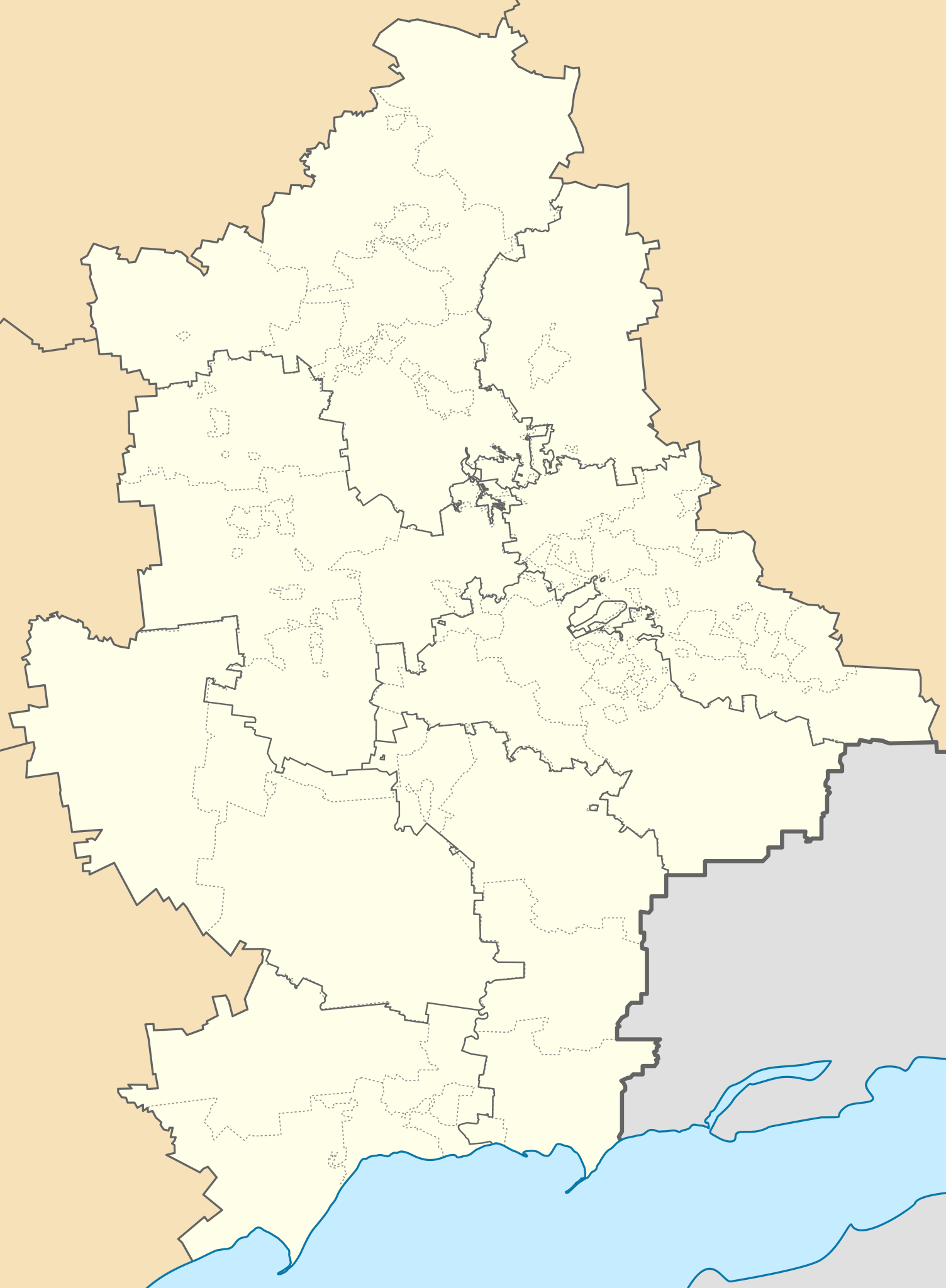
| Description | Русский: Районы Донецкой области Украины по Постановлению Верховной рады от 17 июля 2020 года на фоне старых административных границ районов и городов областного значения (горсоветов) и с отображением неподконтрольных украинским властям территорий непризнанной ДНР. English: Districts of the Donetsk region of Ukraine according to the Decree of the Verkhovna Rada of July 17, 2020 against the background of the old administrative boundaries of districts and cities of regional significance (city councils) and displaying the territories of the unrecognized DPR that are not controlled by the Ukrainian authorities. |
| Date | |
| Source | Own work |
| Author | RosssW |
| SVG development |
Licensing
I, the copyright holder of this work, hereby publish it under the following license:
This file is licensed under the Creative Commons Attribution-Share Alike 4.0 International license.
- You are free:
- to share – to copy, distribute and transmit the work
- to remix – to adapt the work
- Under the following conditions:
- attribution – You must give appropriate credit, provide a link to the license, and indicate if changes were made. You may do so in any reasonable manner, but not in any way that suggests the licensor endorses you or your use.
- share alike – If you remix, transform, or build upon the material, you must distribute your contributions under the same or compatible license as the original.
File history
Click on a date/time to view the file as it appeared at that time.
| Date/Time | Thumbnail | Dimensions | User | Comment | |
|---|---|---|---|---|---|
| current | 04:33, 6 May 2024 | | 489 × 666 (141 KB) | Physeters | small changes |
| 04:52, 3 May 2024 |  | 489 × 666 (141 KB) | Physeters | thin out new raion borders & make them dark grey; make old raion borders a lighter grey and dashed | |
| 01:40, 19 August 2023 |  | 489 × 666 (167 KB) | Physeters | small fix | |
| 14:35, 18 June 2023 |  | 489 × 666 (167 KB) | Yeagvr | The borders have changed, better delete them to consider this file as a location map of the de jure donetsk oblast | |
| 06:56, 7 June 2023 |  | 489 × 666 (193 KB) | Physeters | change the angle of the diagonal lines to better match the original | |
| 06:51, 7 June 2023 |  | 489 × 666 (193 KB) | Physeters | made grey bands transparent on higher detailed version | |
| 22:36, 18 May 2023 |  | 489 × 666 (96 KB) | Cherkash | Reverted to version as of 09:45, 25 August 2020 (UTC) this wasn’t a great improvement as gray bands now covered a lot of borderlines | |
| 00:01, 22 February 2023 |  | 489 × 666 (191 KB) | Physeters | greatly improve the quality of the separatist controlled areas and post 2020 raion borders | |
| 09:45, 25 August 2020 |  | 489 × 666 (96 KB) | RosssW | Uploaded own work with UploadWizard |
File usage
There are no pages that use this file.
Global file usage
The following other wikis use this file:
- Usage on an.wikipedia.org
- Usage on az.wikipedia.org
- Usage on be.wikipedia.org
- Марыупаль
- Горліўка
- Аўдзііўка
- Амвросііўка
- Славянск
- Краматорск
- Вэлыка Навасілка
- Дэбальцэвэ
- Вуглэгірск
- Світладарск
- Пэтрыўка (Дабрапільскі раён)
- Ваздвыжэнка (Бахмуцкі раён)
- Свята-Пакроўскэ
- Бахмут
- Шаблон:На карце/Украіна Данецкая вобласць
- Лыман
- Якаўліўка (Ясынувацкі раён)
- Ясынувата
- Часіў Яр
- Шахтарск
- Дакучаеўск
- Краснагорыўка
- Білазэрскэ
- Білыцкэ
- Янакіевэ
- Сівэрск
- Сэлыдавэ
- Касцянтыніўка (Данецкая вобласць)
- Зугрэс
- Вуглэдар
- Дабрапілля
- Святагірск
- Мырнаград
- Мар’інка
- Салэдар
- Пакроўск (Украіна)
- Курахавэ
- Моспынэ
- Залізнэ
- Гірнык (Данецкая вобласць)
- Бунгэ
- Кальміускэ
- Жданіўка
- Новаазоўск
- Родынскэ
View more global usage of this file.
Metadata
Explore the world

United states
New York

Japan
Tokyo

Singapore
Singapore
