
 Français
 Italiano
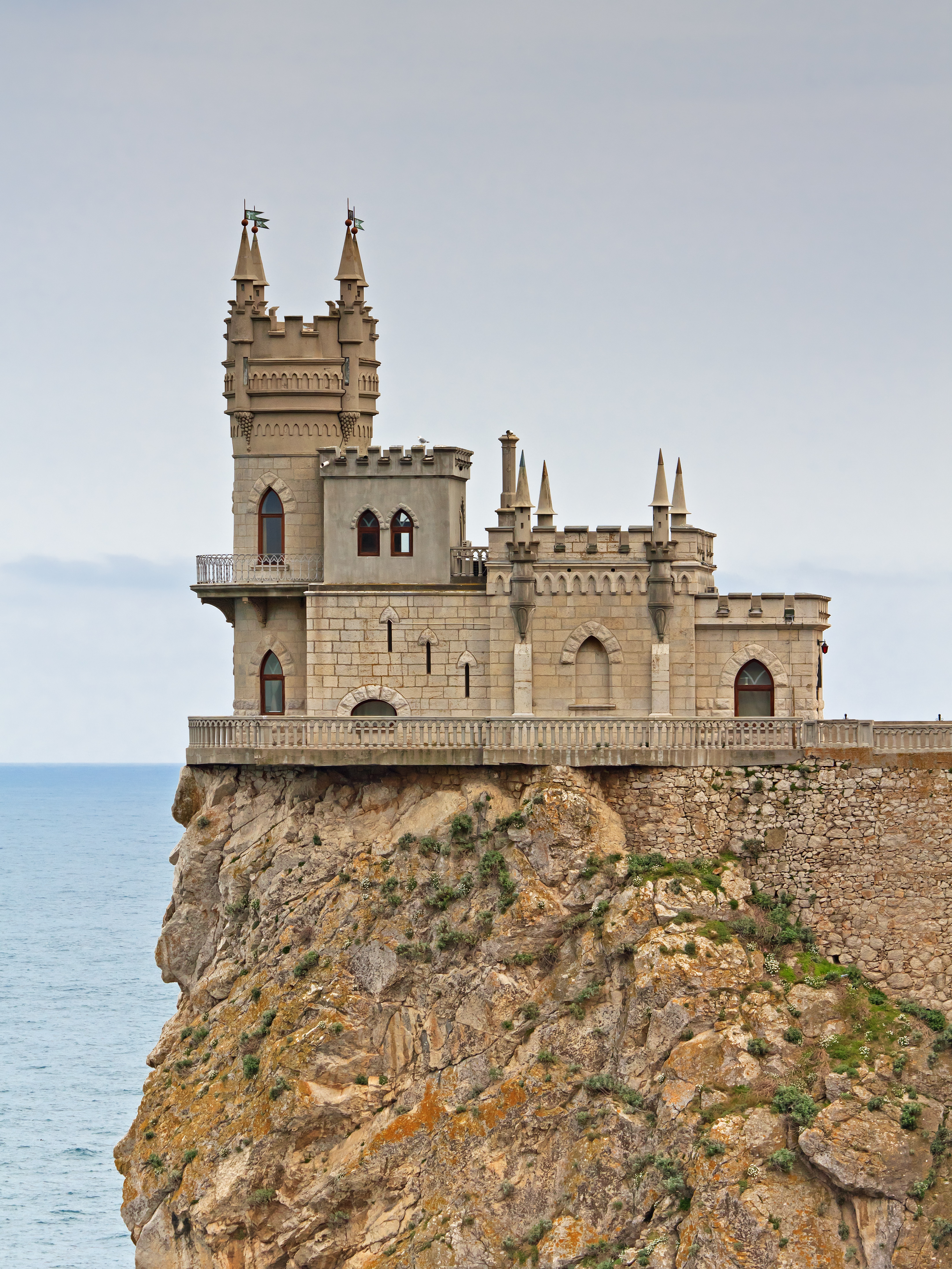
Size of this preview: 450 × 600 pixels. Other resolutions: 180 × 240 pixels | 360 × 480 pixels | 576 × 768 pixels | 768 × 1,024 pixels | 1,536 × 2,048 pixels | 3,290 × 4,386 pixels.
Original file (3,290 × 4,386 pixels, file size: 5.56 MB, MIME type: image/jpeg)
This is a file from the Wikimedia Commons and may be used by other projects. Information from its description page there is shown below. Commons is a freely licensed media file repository. |
Summary
| Description | العربية: قلعة عُش السُنونُو على مقرُبةٍ من گاسپرا، بِمُحافظة يالطا، بِالقرم. Deutsch: Schloss „Schwalbennest“ bei Gaspra auf der Krim English: The Swallow's Nest Castle near Gaspra, Yalta municipality. Crimea. Français : Le château du Nid d'hirondelle, situé sur les bords de la mer Noire à Gaspra, près de Yalta, en Crimée. Polski: Jaskółcze Gniazdo na południowym wybrzeżu Krymu. Português: Castelo do Ninho da Andorinha, próximo a Gaspra, município de Yalta, na Crimeia. Русский: Замок «Ласточкино гнездо» близ поселка Гаспра. Ялтинский горсовет, Крым. Українська: Замок «Ластівчине гніздо» поблизу селища Гаспра. Ялтинська міськрада, Крим. Magyar: A Fecskefészek a Krím félszigeten |
| Date | |
| Source | Own work |
| Author | A.Savin |
| Permission (Reusing this file) | .svg) Just attribute the author: «A.Savin, Wikipedia»; if you have questions — Telegram, or e-mail to [email protected]..svg) Просто укажите в качестве автора: «А.Савин, Википедия»; если есть вопрос — телеграм, или эл.почта на [email protected]. Kennzeichnen Sie einfach als Autor: «A.Savin, Wikipedia»; falls Sie Fragen haben — Telegram, oder E-Mail an [email protected].
Thank you. |
| Camera location | | View this and other nearby images on: OpenStreetMap |
|---|
Assessment
|

This image was selected as picture of the day on Wikimedia Commons for 16 December 2014. It was captioned as follows: Other languages: Français : Le château du Nid d'hirondelle, situé sur les bords de la mer Noire à Gaspra, près de Yalta, en Crimée. Magyar: A Fecskefészek a Krím félszigeten Українська: Замок «Ластівчине гніздо» поблизу селища Гаспра. Ялтинська міськрада, Крим, Україна. |
Licensing
| Copyleft: This work of art is free; you can redistribute it and/or modify it according to terms of the Free Art License. You will find a specimen of this license on the Copyleft Attitude site as well as on other sites. |
This file is licensed under the Creative Commons Attribution-Share Alike 3.0 Unported, 2.5 Generic, 2.0 Generic and 1.0 Generic license.
- You are free:
- to share – to copy, distribute and transmit the work
- to remix – to adapt the work
- Under the following conditions:
- attribution – You must give appropriate credit, provide a link to the license, and indicate if changes were made. You may do so in any reasonable manner, but not in any way that suggests the licensor endorses you or your use.
- share alike – If you remix, transform, or build upon the material, you must distribute your contributions under the same or compatible license as the original.
File history
Click on a date/time to view the file as it appeared at that time.
| Date/Time | Thumbnail | Dimensions | User | Comment | |
|---|---|---|---|---|---|
| current | 21:43, 19 April 2014 | | 3,290 × 4,386 (5.56 MB) | A.Savin | {{User:A.Savin/Photo |Description= {{en|The Swallow's Nest Castle near Gaspra, Yalta municipality. Republic of Crimea.}} {{ru|Замок «Ласточкино гнездо» близ г. Гаспра. Ялтинский регион, Республи... |
File usage
Global file usage
The following other wikis use this file:
- Usage on ar.wikipedia.org
- قلعة عش السنونو
- ويكيبيديا:صور مختارة/أماكن/عمارة
- ويكيبيديا:ترشيحات الصور المختارة/قصر عش السنونو
- ويكيبيديا:صورة اليوم المختارة/أغسطس 2016
- قالب:صورة اليوم المختارة/2016-08-04
- ويكيبيديا:صورة اليوم المختارة/نوفمبر 2019
- قالب:صورة اليوم المختارة/2019-11-01
- ويكيبيديا:صورة اليوم المختارة/أغسطس 2020
- قالب:صورة اليوم المختارة/2020-08-23
- ويكيبيديا:صورة اليوم المختارة/سبتمبر 2023
- قالب:صورة اليوم المختارة/2023-09-14
- Usage on ba.wikipedia.org
- Usage on be-tarask.wikipedia.org
- Usage on be.wikipedia.org
- Usage on crh.wikipedia.org
- Usage on cs.wikipedia.org
- Usage on cv.wikipedia.org
- Usage on de.wikipedia.org
- Usage on de.wikivoyage.org
- Usage on el.wikivoyage.org
- Usage on eo.wikipedia.org
- Usage on es.wikipedia.org
- Usage on es.wikivoyage.org
- Usage on fa.wikipedia.org
- ویکیپدیا:گزیدن نگاره برگزیده/دسامبر-۲۰۱۴
- ویکیپدیا:نگاره روز/اوت ۲۰۱۵
- قلعه آشیانه پرستو
- ویکیپدیا:گزیدن نگاره برگزیده/Crimea South Coast 04-14 img10 Gaspra Swallows Nest.jpg
- بحث کاربر:Maometto97/بایگانی ۳
- الگو:نر/2015-08-02
- الگو:نر محافظت شده/2015-08-02
- ویکیپدیا:نگاره روز/مارس ۲۰۱۸
- ویکیپدیا:نگاره روز/ژانویه ۲۰۲۰
- الگو:نر/2018-03-22
- الگو:نر محافظت شده/2018-03-22
- الگو:نر/2020-01-17
- الگو:نر محافظت شده/2020-01-17
- Usage on fi.wikipedia.org
- Usage on fr.wikipedia.org
View more global usage of this file.
Metadata
Explore the world

United states
New York

Japan
Tokyo

Singapore
Singapore
