
 Français
 Italiano
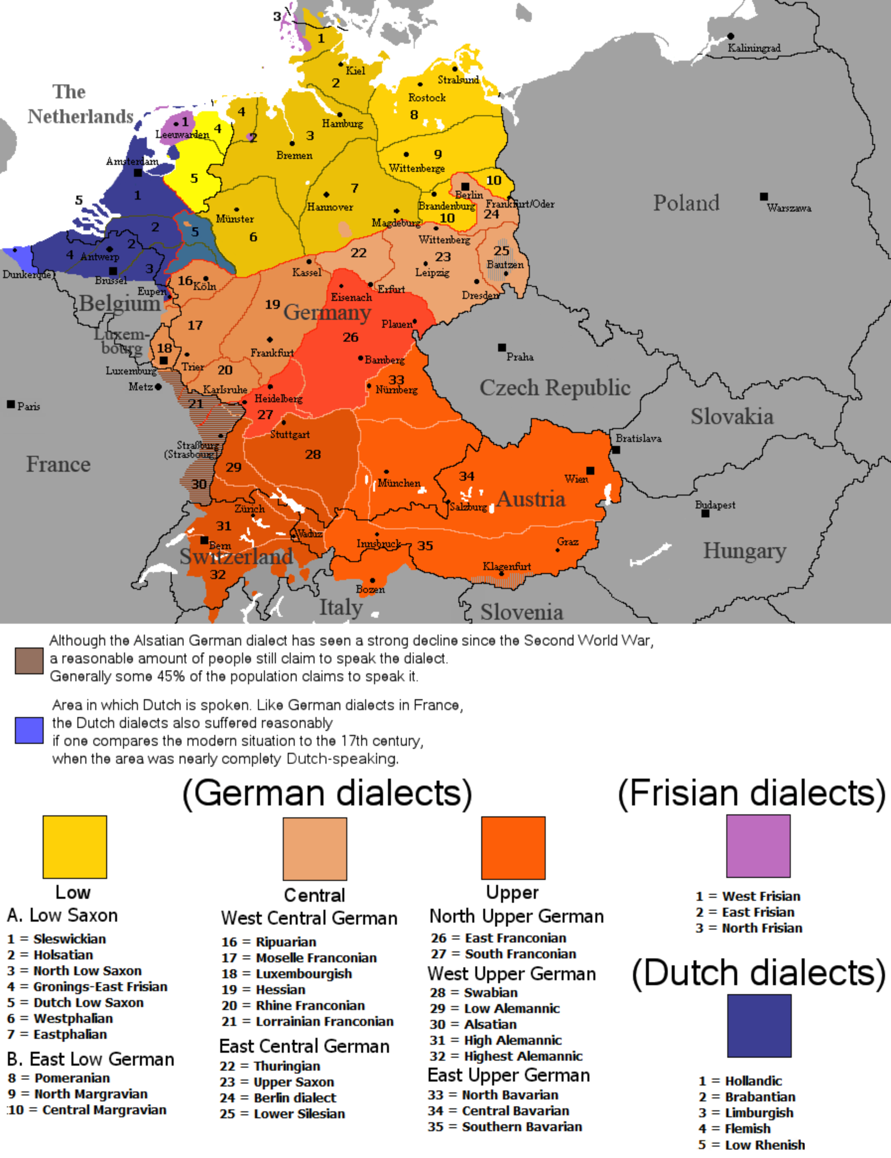
Size of this preview: 462 × 600 pixels. Other resolutions: 185 × 240 pixels | 370 × 480 pixels | 591 × 768 pixels | 789 × 1,024 pixels | 1,796 × 2,332 pixels.
Original file (1,796 × 2,332 pixels, file size: 539 KB, MIME type: image/png)
This is a file from the Wikimedia Commons and may be used by other projects. Information from its description page there is shown below. Commons is a freely licensed media file repository. |

 | This linguistic map image could be re-created using vector graphics as an SVG file. This has several advantages; see Commons:Media for cleanup for more information. If an SVG form of this image is available, please upload it and afterwards replace this template with {{vector version available|new image name}}.It is recommended to name the SVG file “Continental West Germanic languages.svg”—then the template Vector version available (or Vva) does not need the new image name parameter. |
| Description | English: The dialectal ranges (not those of standard languages!) of the Continental West Germanic languages (Dutch/Frisian/German) after 1945 | ||
| Source |
| ||
| Author | Rex Germanus | ||
| Permission (Reusing this file) |
|

File history
Click on a date/time to view the file as it appeared at that time.
| Date/Time | Thumbnail | Dimensions | User | Comment | |
|---|---|---|---|---|---|
| current | 23:04, 25 September 2023 | | 1,796 × 2,332 (539 KB) | Гинц фон Гинценфельд | In dieser Version ist die Westfälische Linie genauer markiert. |
| 22:52, 25 September 2023 |  | 1,796 × 2,332 (538 KB) | Гинц фон Гинценфельд | In dieser Version ist die Westfälische Linie genauer markiert. | |
| 11:26, 25 September 2023 |  | 1,796 × 2,332 (535 KB) | Гинц фон Гинценфельд | In dieser Version ist die Westfälische Linie genauer markiert. | |
| 20:01, 8 August 2017 |  | 898 × 1,166 (166 KB) | E-960 | Corrected location of city markers | |
| 09:19, 6 May 2017 |  | 898 × 1,166 (166 KB) | E-960 | Updated map to focus on Germany and the Benelux, also removed out of date areas, due to migration back to Germany after the fall of the Iron Curtain. | |
| 17:49, 4 February 2017 |  | 1,028 × 1,196 (193 KB) | E-960 | Added place name of Wien, and Český Krumlov in local language. | |
| 17:11, 4 February 2017 |  | 1,028 × 1,196 (193 KB) | E-960 | Adjusted place names reverting them to the local language of each individual country, also fixed the border between Belarus and Ukraine, and areas of German minority in Central and Eastern Europe. | |
| 17:07, 12 August 2016 |  | 1,028 × 1,196 (154 KB) | Kontrollstellekundl | corr: Salzbaurg -> Salzburg Krummau -> Krumau Luxemburgish -> Luxembourgish Upper Sacon -> Upper Saxon + placement of various names | |
| 12:15, 28 July 2014 |  | 1,028 × 1,196 (107 KB) | Crom daba | Shaded sub-dialect groupings a bit different so that they can be differentiated at a glance | |
| 21:57, 4 September 2010 |  | 1,028 × 1,196 (132 KB) | Hans Erren | Geographic border corrections (Borkum, Markerwaard) Western ripuarian border corrected |
File usage
The following page uses this file:
Global file usage
The following other wikis use this file:
- Usage on ace.wikipedia.org
- Usage on af.wikipedia.org
- Usage on azb.wikipedia.org
- Usage on be-tarask.wikipedia.org
- Usage on bg.wikipedia.org
- Usage on ce.wikipedia.org
- Usage on da.wikipedia.org
- Usage on de.wikipedia.org
- Usage on en.wikipedia.org
- Usage on es.wikipedia.org
- Usage on fa.wikipedia.org
- Usage on fr.wikipedia.org
- Usage on ga.wikipedia.org
- Usage on hr.wiktionary.org
- Usage on id.wikipedia.org
- Usage on ja.wikipedia.org
- Usage on lij.wikipedia.org
- Usage on mk.wikipedia.org
- Usage on mn.wikipedia.org
- Usage on pnb.wikipedia.org
- Usage on ro.wikipedia.org
- Usage on ru.wikipedia.org
- Usage on simple.wikipedia.org
- Usage on sl.wikipedia.org
- Usage on sr.wikipedia.org
- Usage on sv.wikipedia.org
- Usage on uk.wikipedia.org
- Usage on zh-min-nan.wikipedia.org
Metadata
Explore the world

United states
New York

Japan
Tokyo

Singapore
Singapore
