
 Français
 Italiano
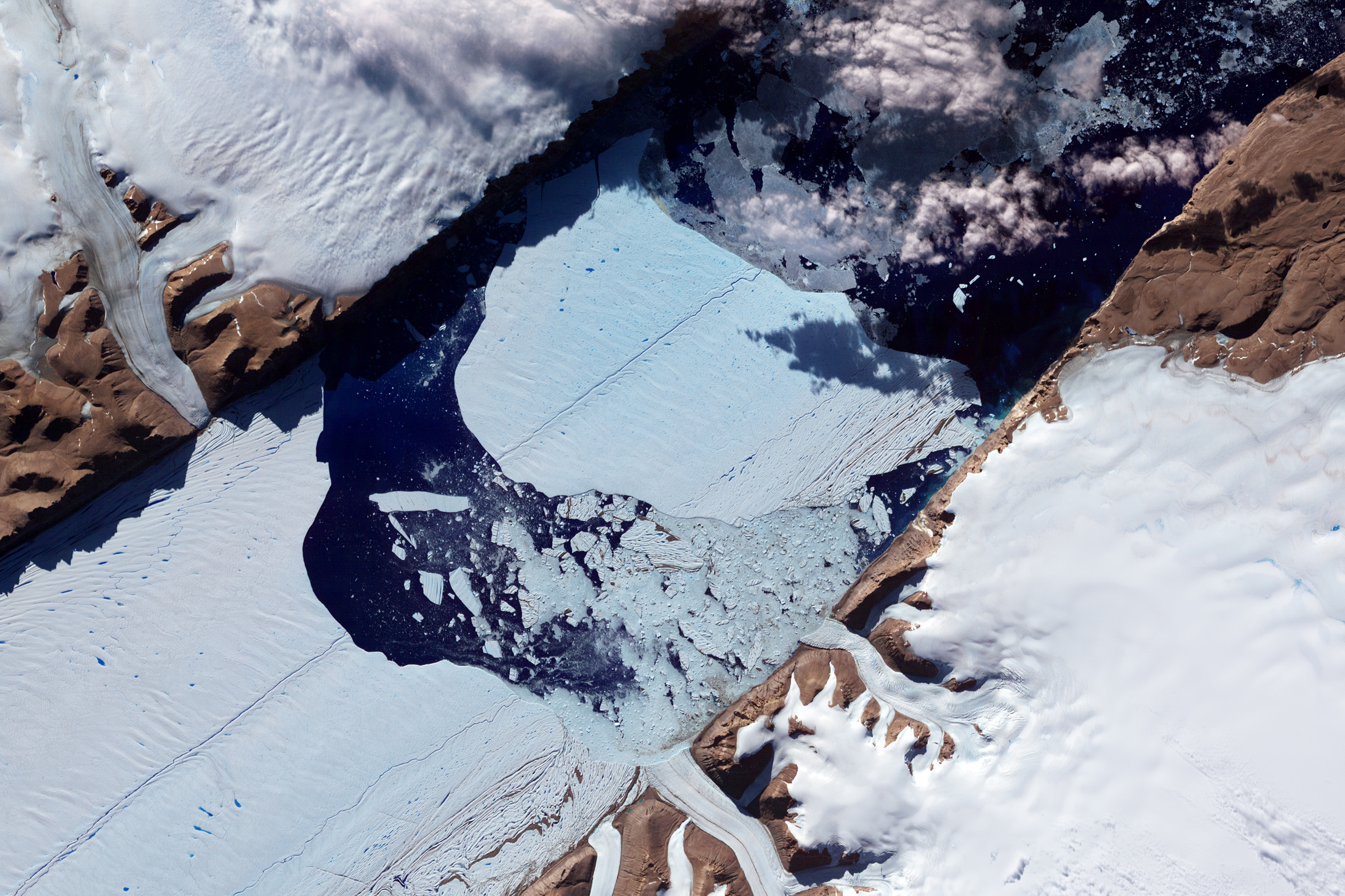
Original file (2,979 × 1,986 pixels, file size: 2.74 MB, MIME type: image/jpeg)
This is a file from the Wikimedia Commons and may be used by other projects. Information from its description page there is shown below. Commons is a freely licensed media file repository. |
Summary
| Description | NASA image acquired July 21, 2012 In July 2012, a massive ice island broke free of the Petermann Glacier in northwestern Greenland. On July 16, the giant iceberg could be seen drifting down the fjord, away from the floating ice tongue from which it calved. On July 21, 2012, the Advanced Spaceborne Thermal Emission and Reflection Radiometer (ASTER) on NASA’s Terra satellite captured this image of the iceberg’s continuing journey. This image has been rotated and north is toward the right. ASTER combines infrared, red, and green wavelengths of light to make false-color images that help to distinguish between water and land. Water is blue, ice and snow vary in color from pale blue to white, and land areas appear brick red and brown. Clouds in the scene cast dark shadows onto the iceberg surface. Similar surface cracks appear on both the Petermann Glacier and the newly formed ice island. Nearly two years ago in July 2010, another large iceberg calved from the Petermann Glacier. That iceberg was estimated at roughly 97 square miles (251 square kilometers). The 2012 iceberg is estimated to be about half as big. This latest calving occurred farther upstream on the Petermann, but nevertheless occurred along a rift that appeared in satellite imagery in 2001. Ted Scambos of the National Snow and Ice Data Center observed melt ponds on the iceberg surface, but stated that the Petermann calving was likely associated with ocean currents rather than surface melt. NASA Earth Observatory image by Jesse Allen and Robert Simmon, using data from NASA/GSFC/METI/ERSDAC/JAROS, and U.S./Japan ASTER Science Team. Caption by Michon Scott. Instrument: Terra - ASTER Credit: NASA Earth Observatory NASA Goddard Space Flight Center enables NASA’s mission through four scientific endeavors: Earth Science, Heliophysics, Solar System Exploration, and Astrophysics. Goddard plays a leading role in NASA’s accomplishments by contributing compelling scientific knowledge to advance the Agency’s mission. Follow us on Twitter Like us on Facebook Find us on Instagram |
| Date | |
| Source | Closeup of the Ice Island from Petermann Glacier |
| Author | NASA Goddard Space Flight Center from Greenbelt, MD, USA |
Licensing
- You are free:
- to share – to copy, distribute and transmit the work
- to remix – to adapt the work
- Under the following conditions:
- attribution – You must give appropriate credit, provide a link to the license, and indicate if changes were made. You may do so in any reasonable manner, but not in any way that suggests the licensor endorses you or your use.
| This image was originally posted to Flickr by NASA Goddard Photo and Video at https://www.flickr.com/photos/24662369@N07/7638834528. It was reviewed on 17 August 2012 by FlickreviewR and was confirmed to be licensed under the terms of the cc-by-2.0. |
| This file is in the public domain in the United States because it was solely created by NASA. NASA copyright policy states that "NASA material is not protected by copyright unless noted". (See Template:PD-USGov, NASA copyright policy page or JPL Image Use Policy.) | ||
 | Warnings:
|
File history
Click on a date/time to view the file as it appeared at that time.
| Date/Time | Thumbnail | Dimensions | User | Comment | |
|---|---|---|---|---|---|
| current | 20:13, 17 August 2012 | | 2,979 × 1,986 (2.74 MB) | Werieth | == {{int:filedesc}} == {{Information |Description=NASA image acquired July 21, 2012 In July 2012, a massive ice island broke free of the Petermann Glacier in northwestern Greenland. On July 16, the giant iceberg could be seen drifting down the fjord, ... |
File usage
The following page uses this file:
Global file usage
The following other wikis use this file:
- Usage on bn.wikivoyage.org
- Usage on ja.wikivoyage.org
Metadata
Explore the world

United states
New York

Japan
Tokyo

Singapore
Singapore
