
 Français
 Italiano
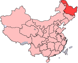
No higher resolution available.
China-Heilongjiang.png (268 × 218 pixels, file size: 31 KB, MIME type: image/png)
This is a file from the Wikimedia Commons and may be used by other projects. Information from its description page there is shown below. Commons is a freely licensed media file repository. |
 | File:China Heilongjiang.svg is a vector version of this file. It should be used in place of this PNG file when not inferior. File:China-Heilongjiang.png → File:China Heilongjiang.svg For more information, see Help:SVG. |  |
en: Location of Heilongjiang Province in the People's Republic of China. See Locator maps of province-level divisions of the People's Republic of China for more information. The striped area is administered by Daxing'anling Prefecture of Heilongjiang, but it is nominally part of Inner Mongolia Autonomous Region.
zh: 黑龍江省在中華人民共和國的位置。另見Locator maps of province-level divisions of the People's Republic of China。加斜杠的地區由黑龍江省大興安嶺地區所管轄,但在名義上為内蒙古自治區的一部分。
 | Permission is granted to copy, distribute and/or modify this document under the terms of the GNU Free Documentation License, Version 1.2 or any later version published by the Free Software Foundation; with no Invariant Sections, no Front-Cover Texts, and no Back-Cover Texts. A copy of the license is included in the section entitled GNU Free Documentation License. |
| This file is licensed under the Creative Commons Attribution-Share Alike 3.0 Unported license. | ||
| ||
| This licensing tag was added to this file as part of the GFDL licensing update. |
File history
Click on a date/time to view the file as it appeared at that time.
| Date/Time | Thumbnail | Dimensions | User | Comment | |
|---|---|---|---|---|---|
| current | 14:45, 28 October 2007 | | 268 × 218 (31 KB) | Croquant | transparent background |
| 21:47, 4 June 2005 |  | 268 × 218 (9 KB) | Ran | '''en''': Location of Heilongjiang Province in the People's Republic of China. See Category:Locator maps of province-level divisions of the People's Republic of China for more information. The striped area is administered by Daxing'anling Prefecture |
File usage
There are no pages that use this file.
Global file usage
The following other wikis use this file:
- Usage on cy.wikipedia.org
- Usage on da.wikipedia.org
- Usage on de.wikipedia.org
- Usage on en.wikipedia.org
- Pingfang, Harbin
- Wikipedia:WikiProject Chinese provinces/Locator maps
- Songjiang Province
- Longjiang County
- Jingpo Lake
- Wanda Mountains
- Mingshui County
- Heitai
- Kedong County
- Bei'an
- Nan'gang, Harbin
- Ang'angxi District
- Diaoshuilou Falls
- Mudan River
- Zhalong Nature Reserve
- Nenjiang Province
- Gannan County
- Nehe
- Shuangcheng, Harbin
- Tangchi, Heilongjiang
- Tieli
- Mishan
- Baoquan, Heilongjiang
- Heihe Aihui Airport
- Yi'an Town, Heilongjiang
- Laha, Heilongjiang
- Muling
- Template:Heilongjiang-geo-stub
- Daxing'anling Prefecture
- Daoli, Harbin
- HLA-B67
- HLA-B59
- Jiangqiao Mongol Ethnic Town
- Wanjia re-education through labor camp
- Nenjiang City
View more global usage of this file.
Explore the world

United states
New York

Japan
Tokyo

Singapore
Singapore
