
 Français
 Italiano
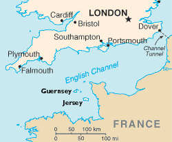
No higher resolution available.
ChannelIslands.png (250 × 207 pixels, file size: 10 KB, MIME type: image/png)
This is a file from the Wikimedia Commons and may be used by other projects. Information from its description page there is shown below. Commons is a freely licensed media file repository. |
Summary
This image was copied from wikipedia:en. The original description was:
Channel Islands
Adapted from map from CIA World Factbook
This image is in the public domain because it contains materials that originally came from the United States Central Intelligence Agency's World Factbook.
|  |
| Annotations | This image is annotated: View the annotations at Commons |
File history
Click on a date/time to view the file as it appeared at that time.
| Date/Time | Thumbnail | Dimensions | User | Comment | |
|---|---|---|---|---|---|
| current | 10:40, 4 July 2005 | | 250 × 207 (10 KB) | HennaBot~commonswiki | This image was copied from wikipedia:en. The original description was: Channel Islands Adapted from map from CIA World Factbook {{PD-USGov-CIA-WF}} en:Image:ChannelIslands.png |
| 10:35, 4 July 2005 |  | 250 × 207 (10 KB) | HennaBot~commonswiki | This image was copied from wikipedia:en. The original description was: Channel Islands Adapted from map from CIA World Factbook {{PD-USGov-CIA-WF}} en:Image:ChannelIslands.png |
File usage
There are no pages that use this file.
Global file usage
The following other wikis use this file:
- Usage on af.wikipedia.org
- Usage on bs.wikipedia.org
- Usage on da.wikipedia.org
- Usage on de.wikipedia.org
- Usage on de.wikivoyage.org
- Usage on en.wikipedia.org
- Usage on en.wikinews.org
- Usage on eo.wikipedia.org
- Usage on fo.wikipedia.org
- Usage on he.wikipedia.org
- Usage on hr.wikipedia.org
- Usage on id.wikipedia.org
- Usage on it.wikipedia.org
- Usage on it.wikivoyage.org
- Usage on no.wikipedia.org
- Usage on oc.wikipedia.org
- Usage on ro.wikipedia.org
- Usage on ru.wikipedia.org
- Usage on sh.wikipedia.org
- Usage on simple.wikipedia.org
- Usage on sk.wikipedia.org
- Usage on sw.wikipedia.org
- Usage on vls.wikipedia.org
Explore the world

United states
New York

Japan
Tokyo

Singapore
Singapore
