
 Français
 Italiano
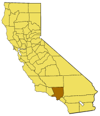
No higher resolution available.
California_map_showing_Los_Angeles_County.png (200 × 231 pixels, file size: 19 KB, MIME type: image/png)
This is a file from the Wikimedia Commons and may be used by other projects. Information from its description page there is shown below. Commons is a freely licensed media file repository. |
Map of Los Angeles county in California. From en:
 | Permission is granted to copy, distribute and/or modify this document under the terms of the GNU Free Documentation License, Version 1.2 or any later version published by the Free Software Foundation; with no Invariant Sections, no Front-Cover Texts, and no Back-Cover Texts. A copy of the license is included in the section entitled GNU Free Documentation License. |
| This file is licensed under the Creative Commons Attribution-Share Alike 3.0 Unported license. | ||
| ||
| This licensing tag was added to this file as part of the GFDL licensing update. |
File history
Click on a date/time to view the file as it appeared at that time.
| Date/Time | Thumbnail | Dimensions | User | Comment | |
|---|---|---|---|---|---|
| current | 13:37, 13 July 2005 | | 200 × 231 (19 KB) | Pyramide~commonswiki | Map of Los Angeles county in California. From en: {{GFDL}} Category:Maps of counties in California |
File usage
There are no pages that use this file.
Global file usage
The following other wikis use this file:
- Usage on bg.wikipedia.org
- Usage on cs.wikipedia.org
- Usage on en.wikipedia.org
- Valley Hunt Club
- Frank G. Bonelli Regional Park
- Santa Fe Dam Recreation Area
- Averill Park
- Beach Cities
- Antelope Acres, California
- Del Sur, California
- Llano, California
- Valyermo, California
- Mount Disappointment (California)
- Cahuenga Pass
- Earl Burns Miller Japanese Garden
- California Botanic Garden
- Mount Lowe (California)
- Orange Curtain
- Plummer Park
- Compton station
- La Cienega Park
- San Fernando Gardens
- Mar Vista Gardens
- Housing Authority of the City of Los Angeles
- Saddleback Butte State Park
- East Village, Long Beach, California
- Batchelder House (Pasadena, California)
- Vermont/Sunset station
- Lomita Railroad Museum
- Grand/LATTC station
- Broadway Corridor, Long Beach, California
- 1st Street station (Los Angeles Metro)
- Downtown Long Beach station
- Pacific Avenue station
- Anaheim Street station
- 5th Street station (Los Angeles Metro)
- Pacific Coast Highway station (A Line)
- Willow Street station
- Del Amo station
- Artesia station
- 103rd Street/Watts Towers station
- Firestone station
- Florence station (Los Angeles Metro)
- Slauson station (A Line)
- Vernon station
- Washington station (Los Angeles Metro)
- San Pedro Street station
- Whittier Fault
- Morris Reservoir
- Chinatown station (Los Angeles Metro)
- Westlake Golf Course
View more global usage of this file.
Explore the world

United states
New York

Japan
Tokyo

Singapore
Singapore
