
 Français
 Italiano
Size of this PNG preview of this SVG file: 800 × 366 pixels. Other resolutions: 320 × 147 pixels | 640 × 293 pixels | 1,024 × 469 pixels | 1,280 × 586 pixels | 2,560 × 1,172 pixels | 1,920 × 879 pixels.
Original file (SVG file, nominally 1,920 × 879 pixels, file size: 489 KB)
This is a file from the Wikimedia Commons and may be used by other projects. Information from its description page there is shown below. Commons is a freely licensed media file repository. |
Summary
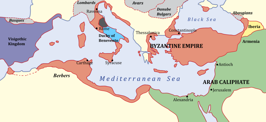
| Description | English: The Byzantine Empire in 650 - by this year it had lost all of its southern provinces except the Exarchate of Africa. Deutsch: Der Mittelmeerraum um 650. Die Grenzen des byzantinischen Reiches von 650 n. Chr. unter Kaiser Konstans II. Die Grenzen des oströmischen Reiches (orange) um 650 n. Chr. Der Gebietsstand deckt sich weitgehend mit jenem Territorium, das dem Römischen Reich in der Reichskrise des 3. Jahrhunderts – unter gänzlich anderen geopolitischen Rahmenbedingungen – unter Kaiser Gallienus nach der Sezession des Imperium Galliarum und des Sonderreichs von Palmyra verblieben war. Français : L'Empire byzantin en 650. L'empire byzantin en 650 après les conquêtes arabes et la chute de l'empire sassanide. Italiano: L'Impero bizantino e il Califfato nel 650 ca. L'Impero bizantino nel 650 ca., dopo le conquiste islamiche. L'Impero Bizantino nell'anno 650. Come si nota dalla cartina, tutte le province meridionali erano già perse e occupate dagli arabi. L'Impero bizantino nel 650 ca., dopo le conquiste islamiche. Polski: Cesarstwo Bizantyńskie po podbojach arabskich i upadku państwa Sasanidów. 日本語: コンスタンス2世治下、650年頃の東ローマ帝国. Norsk bokmål: Verden ved Middelhavet i 650 etter at araberne hadde erobet Egypt og Syria fra det bysantinske riket. Østromerriket rundt år 650 under Justinians farfar, keiser Konstans II. Bahasa Indonesia: Kekaisaran Bizantium pada 650 - pada masa ini Bizantium kehilangan seluruh provinsi selatannya kecuali Keeksarkaan Afrika. Tiếng Việt: Đế quốc Đông La Mã vào năm 650 dưới thời Konstans II. Đông La Mã vào năm 650 dưới thời Konstans II. 한국어: 650년의 비잔티움 제국. 이 해에 제국은 카르타고 관구를 제외한 나머지 남부 속주를 전부 잃었다. Български: Граници на Византийската империя, ок. 650 г. العربية: الإمبراطورية البيزنطية 650، بحلول هذه السنة كانت قد فقدت كامل مقاطعاتها الجنوبية عدا مقاطعة قرطاج. Slovenščina: Sredozemlja leta 650 po arabski osvojitvi Egipta in Sirije. ไทย: จักรวรรดิไบแซนไทน์ ปี ค.ศ. 650. Беларуская: Тэрыторыі Візантыі ў 650 годзе. Беларуская (тарашкевіца): Тэрыторыі Бізантыі ў 650 годзе. Հայերեն: Բյուզանդական կայսրությունը 650 թ-ին, երբ կայսրությունը բացառությամբ Կարթագենի կորցրել էր իր բոլոր հարավային նահանգները արաբներին:. |
| Date | (UTC) |
| Source | Own work using:
|
| Author |
|
| Other versions | []
|


| This is a retouched picture, which means that it has been digitally altered from its original version. Modifications: SVG. The original can be viewed here: Byzantiumby650AD.JPG:
|
Licensing
I, the copyright holder of this work, hereby publish it under the following licenses:
This file is licensed under the Creative Commons Attribution-Share Alike 3.0 Unported license.
- You are free:
- to share – to copy, distribute and transmit the work
- to remix – to adapt the work
- Under the following conditions:
- attribution – You must give appropriate credit, provide a link to the license, and indicate if changes were made. You may do so in any reasonable manner, but not in any way that suggests the licensor endorses you or your use.
- share alike – If you remix, transform, or build upon the material, you must distribute your contributions under the same or compatible license as the original.
 | Permission is granted to copy, distribute and/or modify this document under the terms of the GNU Free Documentation License, Version 1.2 or any later version published by the Free Software Foundation; with no Invariant Sections, no Front-Cover Texts, and no Back-Cover Texts. A copy of the license is included in the section entitled GNU Free Documentation License. |
You may select the license of your choice.
Original upload log
This image is a derivative work of the following images:
- File:Byzantiumby650AD.JPG licensed with Cc-by-sa-3.0, GFDL
- 2008-05-01T13:10:24Z Killroyus 800x370 (48303 Bytes) {{Information |Description= |Source=[[w:en:Byzantiumby650AD.JPG|english wikipedia]] |Date= |Author=[[w:en:User:Justinian43|Justinian43]] |Permission= |other_versions= }}
Uploaded with derivativeFX
File history
Click on a date/time to view the file as it appeared at that time.
| Date/Time | Thumbnail | Dimensions | User | Comment | |
|---|---|---|---|---|---|
| current | 18:18, 15 April 2023 | | 1,920 × 879 (489 KB) | Antisyntagmatarchos | The Byzantine coastal strip was longer and more narrow. |
| 10:32, 31 October 2012 |  | 924 × 423 (669 KB) | Cplakidas | various tweaks and corrections (the Balkans were mostly lost to the Slavs, Tripolitania and Cyrenaica were still in Byz. hands in 650, Septum likewise) | |
| 09:44, 11 December 2011 |  | 924 × 423 (635 KB) | Hoodinski | minor | |
| 18:23, 9 December 2011 |  | 925 × 422 (644 KB) | Hoodinski | == {{int:filedesc}} == {{Information |Description=A Map of the Byzantine Empire by 650 AD |Source=*File:Byzantiumby650AD.JPG |Date=2011-12-09 18:22 (UTC) |Author=*File:Byzantiumby650AD.JPG: Justinian43 *derivative wor |
File usage
The following page uses this file:
Global file usage
The following other wikis use this file:
- Usage on ar.wikipedia.org
- Usage on arz.wikipedia.org
- Usage on azb.wikipedia.org
- Usage on be-tarask.wikipedia.org
- Usage on be.wikipedia.org
- Usage on bg.wikipedia.org
- Usage on bn.wikipedia.org
- Usage on bn.wikivoyage.org
- Usage on bs.wikipedia.org
- Usage on ca.wikipedia.org
- Usage on da.wikipedia.org
- Usage on de.wikipedia.org
- Usage on el.wikipedia.org
- Usage on en.wikipedia.org
- History of Islam
- 650
- Classical antiquity
- Roman Egypt
- Late antiquity
- Early Muslim conquests
- Roman–Persian wars
- Byzantine Empire under the Heraclian dynasty
- List of Byzantine wars
- Typos of Constans
- Timeline of Eastern Orthodoxy in Greece (33–717)
- User:Kazkaskazkasako/Books/History
- User:Cplakidas/Sandbox/Byzantine-Arab1
- Talk:Dabiq, Syria
- Byzantine Anatolia
- Talk:Mu'awiya I/Temp
- User:Vitzque/byzantineottoman
- Byzantine North Africa
- User:Arman ad60/sandbox
- Martinus (son of Heraclius)
- Wikipedia:Today's featured article/November 2022
- David (son of Heraclius)
- User:Gog the Mild/Blurbs/Archive 2
- Wikipedia:Today's featured article/November 25, 2022
- Wikipedia:Main Page history/2022 November 25
- Wikipedia:Main Page history/2022 November 25b
View more global usage of this file.
Metadata
Explore the world

United states
New York

Japan
Tokyo

Singapore
Singapore
