
 Français
 Italiano
Size of this PNG preview of this SVG file: 204 × 377 pixels. Other resolutions: 130 × 240 pixels | 260 × 480 pixels | 415 × 768 pixels | 554 × 1,024 pixels | 1,108 × 2,048 pixels.
Original file (SVG file, nominally 204 × 377 pixels, file size: 78 KB)
This is a file from the Wikimedia Commons and may be used by other projects. Information from its description page there is shown below. Commons is a freely licensed media file repository. |
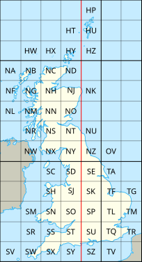
| Description | English: The en:British national grid reference system |
| Date | (UTC) |
| Source | |
| Author |
|
| Other versions | |

This file is licensed under the Creative Commons Attribution-Share Alike 3.0 Unported license.
- You are free:
- to share – to copy, distribute and transmit the work
- to remix – to adapt the work
- Under the following conditions:
- attribution – You must give appropriate credit, provide a link to the license, and indicate if changes were made. You may do so in any reasonable manner, but not in any way that suggests the licensor endorses you or your use.
- share alike – If you remix, transform, or build upon the material, you must distribute your contributions under the same or compatible license as the original.
Original upload log
This image is a derivative work of the following images:
- File:National_Grid_for_Great_Britain_with_central_meridian.gif licensed with Cc-by-sa-3.0-migrated, GFDL
- 2010-02-23T23:22:36Z MansLaughter 235x434 (8630 Bytes) {{Information |Description= |Source=*[[:File:National_Grid_for_Great_Britain_with_central_meridian.png|]] |Date=2010-02-23 23:19 (UTC) |Author=*[[:File:National_Grid_for_Great_Britain_with_central_meridian.png|]]: ~~~ *deriva
- File:United_Kingdom_and_North-West_France.svg licensed with Cc-by-sa-3.0
- 2010-04-26T11:43:17Z Pethrus 270x482 (59564 Bytes) {{Information |Description={{en|Map of the United Kingdom and the North-East of France}}{{fr|Carte des îles britanniques et du Nord-Ouest de la France}} |Source=*[[:File:Europe_blank_laea_location_map.svg|]] |Date=2010-04-26
Uploaded with derivativeFX
File history
Click on a date/time to view the file as it appeared at that time.
| Date/Time | Thumbnail | Dimensions | User | Comment | |
|---|---|---|---|---|---|
| current | 20:06, 8 July 2010 | | 204 × 377 (78 KB) | Nandhp | Remove temporary data (reference to original raster image) |
| 20:05, 8 July 2010 |  | 204 × 377 (83 KB) | Nandhp | {{Information |Description={{en|The en:British national grid reference system}} |Source=*File:National_Grid_for_Great_Britain_with_central_meridian.gif *File:United_Kingdom_and_North-West_France.svg |Date=2010-07-08 20:03 (UTC) |Author=*[ |
File usage
The following page uses this file:
Global file usage
The following other wikis use this file:
- Usage on de.wikipedia.org
- Usage on en.wikipedia.org
- Usage on fr.wikipedia.org
- Usage on nl.wikipedia.org
- Usage on simple.wikipedia.org
- Usage on zh.wikipedia.org
Metadata
Explore the world

United states
New York

Japan
Tokyo

Singapore
Singapore
