
 Français
 Italiano
Size of this PNG preview of this SVG file: 800 × 522 pixels. Other resolutions: 320 × 209 pixels | 640 × 417 pixels | 1,024 × 668 pixels | 1,280 × 835 pixels | 2,560 × 1,670 pixels | 874 × 570 pixels.
Original file (SVG file, nominally 874 × 570 pixels, file size: 1.15 MB)
This is a file from the Wikimedia Commons and may be used by other projects. Information from its description page there is shown below. Commons is a freely licensed media file repository. |
Summary
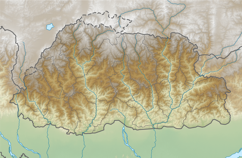
| Description | English: Relief map of Bhutan. Same boundaries as File:Bhutan location map.svg. Relief with STRM30, rivers from Landsat imagery. |
| Date | |
| Source | Derivative of File:Bhutan location map.svg |
| Author | Own work based on User:NNW |
Licensing
This file is licensed under the Creative Commons Attribution-Share Alike 3.0 Unported license.
- You are free:
- to share – to copy, distribute and transmit the work
- to remix – to adapt the work
- Under the following conditions:
- attribution – You must give appropriate credit, provide a link to the license, and indicate if changes were made. You may do so in any reasonable manner, but not in any way that suggests the licensor endorses you or your use.
- share alike – If you remix, transform, or build upon the material, you must distribute your contributions under the same or compatible license as the original.
File history
Click on a date/time to view the file as it appeared at that time.
| Date/Time | Thumbnail | Dimensions | User | Comment | |
|---|---|---|---|---|---|
| current | 04:19, 5 April 2021 | | 874 × 570 (1.15 MB) | C1MM | Uploaded a work by Own work based on User:NNW from Derivative of File:Bhutan location map.svg with UploadWizard |
File usage
There are no pages that use this file.
Global file usage
The following other wikis use this file:
- Usage on ca.wikipedia.org
- Usage on en.wikipedia.org
- Gangkhar Puensum
- Jomolhari
- Mount Jitchu Drake
- Tongshanjiabu
- Tala Hydroelectric Power Station
- Motithang Takin Preserve
- Phobjikha Valley
- Jigme Singye Wangchuck National Park
- Module:Location map/data/Bhutan/doc
- Kangphu Kang
- Dochula Pass
- Dhur (river)
- Module:Location map/data/Bhutan
- User:DutchTreat/Projects/Places
- User:Ty654/List of earthquakes from 1940-1949 exceeding magnitude 6+
- User:Ty654/List of earthquakes from 2005-2009 exceeding magnitude 6+
- Chomolhari Kang
- Tarina Tsho
- Buli Tsho
- Jimilang Tsho
- Adha Tsho
- Masang Kang
- Teri Kang
- Tsenda Kang
- Lawa La
- Pele La
- Chura Kang
- Usage on hr.wikipedia.org
- Usage on ka.wikipedia.org
- Usage on ms.wikipedia.org
- Usage on ne.wikipedia.org
- Usage on sl.wikipedia.org
- Usage on uz.wikipedia.org
Metadata
Explore the world

United states
New York

Japan
Tokyo

Singapore
Singapore
