
 Français
 Italiano
Size of this PNG preview of this SVG file: 454 × 599 pixels. Other resolutions: 182 × 240 pixels | 364 × 480 pixels | 582 × 768 pixels | 776 × 1,024 pixels | 1,552 × 2,048 pixels | 851 × 1,123 pixels.
Original file (SVG file, nominally 851 × 1,123 pixels, file size: 575 KB)
This is a file from the Wikimedia Commons and may be used by other projects. Information from its description page there is shown below. Commons is a freely licensed media file repository. |
Summary
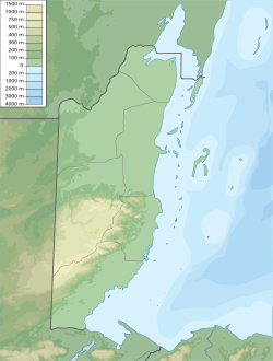
| Description | Map of Belize, parameters same as Belize_location_map.svg (but apparently without the N/S stretching) |
| Date | |
| Source | Own work |
| Author | Urutseg |
Licensing
I, the copyright holder of this work, hereby publish it under the following license:
| This file is made available under the Creative Commons CC0 1.0 Universal Public Domain Dedication. | |
| The person who associated a work with this deed has dedicated the work to the public domain by waiving all of their rights to the work worldwide under copyright law, including all related and neighboring rights, to the extent allowed by law. You can copy, modify, distribute and perform the work, even for commercial purposes, all without asking permission.
|
File history
Click on a date/time to view the file as it appeared at that time.
| Date/Time | Thumbnail | Dimensions | User | Comment | |
|---|---|---|---|---|---|
| current | 00:28, 24 January 2018 | | 851 × 1,123 (575 KB) | Kaldari | Fixing border between Belize and Mexico in Ambergris Caye. Also removing partial maritime border line. |
| 17:16, 10 March 2011 |  | 851 × 1,123 (569 KB) | Urutseg |
File usage
There are no pages that use this file.
Global file usage
The following other wikis use this file:
- Usage on ar.wikipedia.org
- Usage on ast.wikipedia.org
- Usage on az.wikipedia.org
- Usage on ba.wikipedia.org
- Usage on be-tarask.wikipedia.org
- Usage on be.wikipedia.org
- Usage on bg.wikipedia.org
- Usage on bn.wikipedia.org
- Usage on bs.wikipedia.org
- Usage on ceb.wikipedia.org
- Usage on ckb.wikipedia.org
- Usage on cs.wikipedia.org
- Usage on da.wikipedia.org
- Usage on de.wikipedia.org
- Belize
- Ladyville
- Caye Caulker
- Ambergris Caye
- Maya Mountains
- Shipyard
- Victoria Peak (Belize)
- Vorlage:Positionskarte Belize
- Doyle’s Delight
- Wikipedia:Kartenwerkstatt/Positionskarten/Nordamerika
- Turneffe
- Blackadore Caye
- Caye Chapel
- Cayo Espanto
- Goff’s Caye
- Half Moon Caye
- St. George’s Caye
- Laughing Bird Caye
- Moho Caye
- Long Caye
- Lighthouse Reef
- Aguacate Lagoon
- Honey Camp Lagoon
- Benutzer:Shi Annan/Cockscomb Basin Wildlife Sanctuary
- Twin Cays
- Sandbore Caye
- Harvest Caye
View more global usage of this file.
Metadata
Explore the world

United states
New York

Japan
Tokyo

Singapore
Singapore
