
 Français
 Italiano
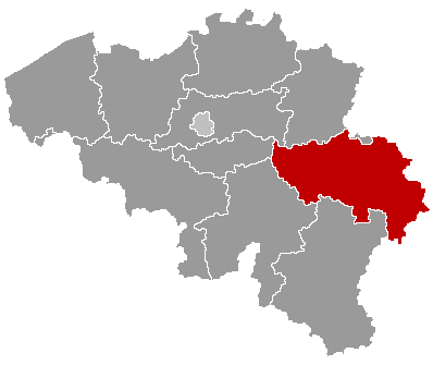
No higher resolution available.
Belgieluik.png (398 × 335 pixels, file size: 6 KB, MIME type: image/png)
This is a file from the Wikimedia Commons and may be used by other projects. Information from its description page there is shown below. Commons is a freely licensed media file repository. |
Summary
| Description | Map of Belgium with the 3 regions together, with the province of Liège colored red. |
| Date | |
| Source | Wikimedia Commons (Article 'Maps_of_Belgium') |
| Author | User 'Morwen' |
| Permission (Reusing this file) | none needed , seen the GNU Free Documentation License. |
Licensing
 | Permission is granted to copy, distribute and/or modify this document under the terms of the GNU Free Documentation License, Version 1.2 or any later version published by the Free Software Foundation; with no Invariant Sections, no Front-Cover Texts, and no Back-Cover Texts. A copy of the license is included in the section entitled GNU Free Documentation License. |
| This file is licensed under the Creative Commons Attribution-Share Alike 3.0 Unported license. | ||
| ||
| This licensing tag was added to this file as part of the GFDL licensing update. |
File history
Click on a date/time to view the file as it appeared at that time.
| Date/Time | Thumbnail | Dimensions | User | Comment | |
|---|---|---|---|---|---|
| current | 18:58, 24 May 2006 | | 398 × 335 (6 KB) | Btrs | {{Information| |Description= Map of Belgium with the 3 regions togheter , with the province of Liège colored red. |Source=Wikimedia Commons (Article 'Maps_of_Belgium') |Date=24 May 2006 |Author=User 'Morwen' |Permission=none needed , seen the GNU Free Do |
File usage
There are no pages that use this file.
Global file usage
The following other wikis use this file:
- Usage on ar.wikipedia.org
- Usage on bg.wikipedia.org
- Лиеж
- Лиеж (провинция)
- Уанз
- Юи
- Верлен
- Клавие
- Ерстал
- Сен Никола (Белгия)
- Вервие
- Вервие (окръг)
- Шаблон:Провинция Лиеж
- Амел
- Бален (Лиеж)
- Бург Ройланд
- Бюлинген
- Бютгенбах
- Келмис
- Лонцен
- Ойпен
- Ререн
- Санкт Вит
- Велкенрат
- Дизон
- Ерв
- Жале
- Лиерньо
- Лимбур
- Малмеди
- Обел (Белгия)
- Олн
- Пепенстер
- Пломбиер
- Ставело
- Стумон
- Тимистер-Клермон
View more global usage of this file.
Explore the world

United states
New York

Japan
Tokyo

Singapore
Singapore
