
 Français
 Italiano
Size of this preview: 450 × 600 pixels. Other resolutions: 180 × 240 pixels | 360 × 480 pixels | 576 × 768 pixels | 768 × 1,024 pixels | 2,112 × 2,816 pixels.
Original file (2,112 × 2,816 pixels, file size: 3.37 MB, MIME type: image/jpeg)
This is a file from the Wikimedia Commons and may be used by other projects. Information from its description page there is shown below. Commons is a freely licensed media file repository. |
| This is an image of a place or building that is listed on the National Register of Historic Places in the United States of America. Its reference number is 66000606. |
| Camera location | | View this and other nearby images on: OpenStreetMap |
|---|
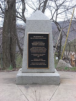
| Description | Streetside view of the Beginning Point of the U.S. Public Land Survey, a monument marking the site that served as the basis for the entire Public Land Survey System — the system by which most of the United States, outside of the original colonies, was surveyed. Located on the Ohio/Pennsylvania border east of downtown East Liverpool, Ohio, it is split between the city of East Liverpool and the borough of Ohioville in Beaver County, Pennsylvania. Erected in 1881 by a joint commission of Ohio and Pennsylvania surveyors, the monument was declared a National Historic Landmark in 1966. The road on which it lies is Ohio State Route 39 and Pennsylvania Route 68. | ||
| Date | Taken on 28 March 2009 | ||
| Source | Own work | ||
| Author | User:Nyttend | ||
| Permission (Reusing this file) |
| ||
| Other versions |  Ohio and Ohio and  Pennsylvania sides of the monument Pennsylvania sides of the monument |
File history
Click on a date/time to view the file as it appeared at that time.
| Date/Time | Thumbnail | Dimensions | User | Comment | |
|---|---|---|---|---|---|
| current | 04:29, 28 March 2009 | | 2,112 × 2,816 (3.37 MB) | Nyttend | {{Location|40|38|33|N|80|31|10|W}} {{Information |Description=Streetside view of the {{w|Beginning Point of the U.S. Public Land Survey}}, a monument marking the site that served as the basis for the entire {{w|Public Land Survey System}} — the system b |
File usage
The following page uses this file:
Global file usage
The following other wikis use this file:
- Usage on ca.wikipedia.org
- Usage on de.wikipedia.org
- Usage on en.wikipedia.org
- Public Land Survey System
- List of Historic Civil Engineering Landmarks
- Point of beginning
- List of National Historic Landmarks in Pennsylvania
- List of National Historic Landmarks in Ohio
- Beginning Point of the U.S. Public Land Survey
- National Register of Historic Places listings in Columbiana County, Ohio
- National Register of Historic Places listings in Beaver County, Pennsylvania
- List of Pennsylvania state historical markers in Beaver County
- User talk:Dthomsen8/List PA Test
- Usage on es.wikipedia.org
- Usage on fr.wikipedia.org
- Usage on hu.wikipedia.org
- Usage on it.wikipedia.org
- Usage on ja.wikipedia.org
- Usage on pt.wikipedia.org
- Usage on tl.wikipedia.org
- Usage on ur.wikipedia.org
- Usage on vi.wikipedia.org
- Usage on www.wikidata.org
- Usage on zh.wikipedia.org
Metadata
Explore the world

United states
New York

Japan
Tokyo

Singapore
Singapore
