
 Français
 Italiano
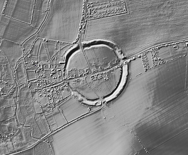
No higher resolution available.
Avebury-SU1025069970.png (626 × 515 pixels, file size: 422 KB, MIME type: image/png)
This is a file from the Wikimedia Commons and may be used by other projects. Information from its description page there is shown below. Commons is a freely licensed media file repository. |
Summary
| Description | English: Topographic rendering of the Avebury site using LIDAR imagery with gradient shading. |
| Date | |
| Source | https://houseprices.io/lab/lidar/map?ref=SU1025069970 |
| Author | LIDAR data (C) Environment Agency & Natural Resources Wales released under the Open Government License. LIDAR map rendering provided by houseprices.io free to use under Creative Commons Attribution License CC BY 4.0 |
UK grid reference SU1025069970
Licensing
This file is licensed under the Creative Commons Attribution-Share Alike 4.0 International license.
- You are free:
- to share – to copy, distribute and transmit the work
- to remix – to adapt the work
- Under the following conditions:
- attribution – You must give appropriate credit, provide a link to the license, and indicate if changes were made. You may do so in any reasonable manner, but not in any way that suggests the licensor endorses you or your use.
- share alike – If you remix, transform, or build upon the material, you must distribute your contributions under the same or compatible license as the original.
File history
Click on a date/time to view the file as it appeared at that time.
| Date/Time | Thumbnail | Dimensions | User | Comment | |
|---|---|---|---|---|---|
| current | 14:38, 14 February 2021 | | 626 × 515 (422 KB) | Mikhailfranco | Uploaded a work by LIDAR data (C) Environment Agency & Natural Resources Wales released under the Open Government License. LIDAR map rendering provided by houseprices.io free to use under Creative Commons Attribution License CC BT 4,0 from https://houseprices.io/lab/lidar/map?ref=SU1025069970 with UploadWizard |
File usage
There are no pages that use this file.
Global file usage
The following other wikis use this file:
- Usage on en.wikipedia.org
- Usage on fr.wikipedia.org
Metadata
Explore the world

United states
New York

Japan
Tokyo

Singapore
Singapore
