
 Français
 Italiano
Size of this PNG preview of this SVG file: 800 × 501 pixels. Other resolutions: 320 × 200 pixels | 640 × 400 pixels | 1,024 × 641 pixels | 1,280 × 801 pixels | 2,560 × 1,602 pixels | 1,042 × 652 pixels.
Original file (SVG file, nominally 1,042 × 652 pixels, file size: 5.55 MB)
This is a file from the Wikimedia Commons and may be used by other projects. Information from its description page there is shown below. Commons is a freely licensed media file repository. |
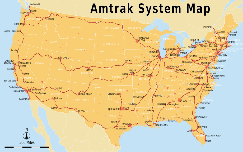
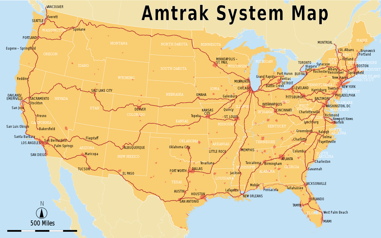
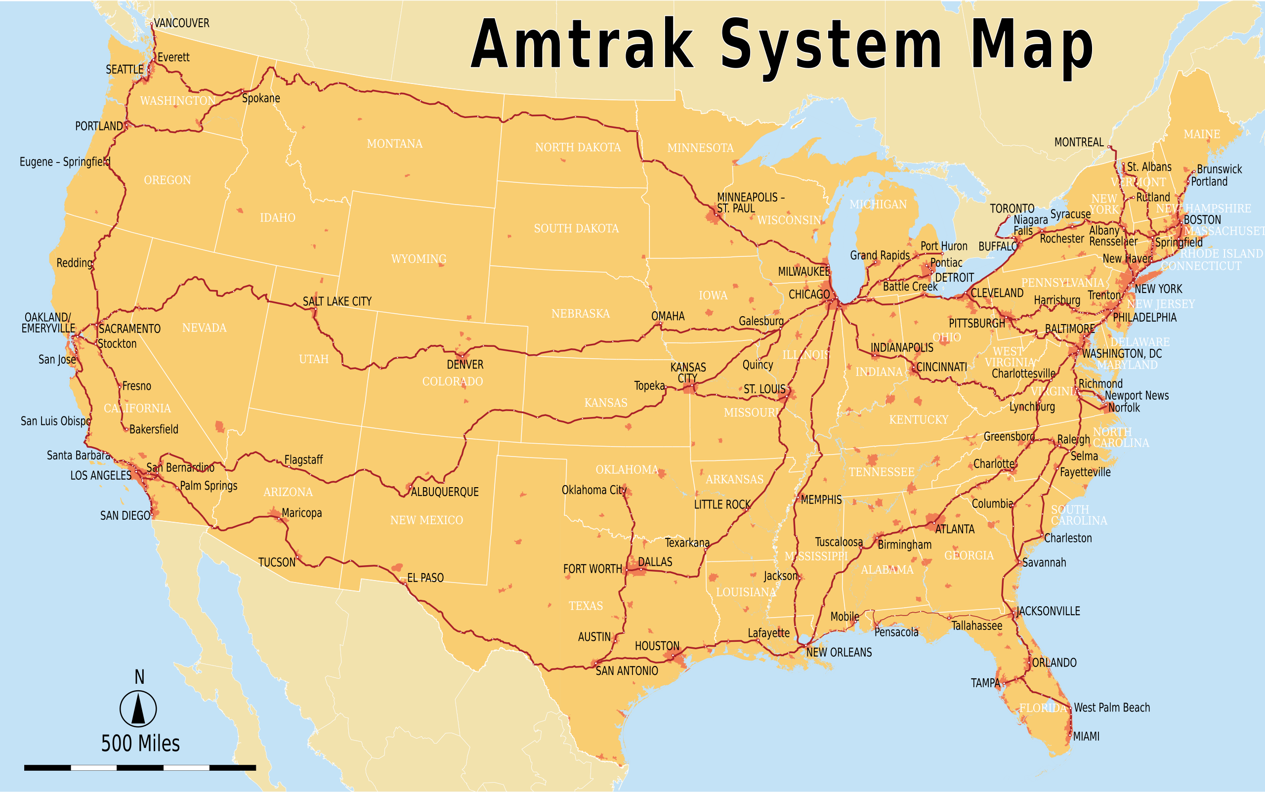
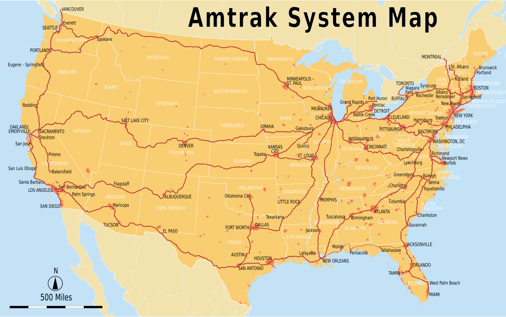
| Description | English: Geographically accurate Amtrak system map with major stations marked. The Sunset Limited section between New Orleans and Orlando is currently suspended. This map is accurate up to the Norfolk and Brunswick extensions of late 2012. |
| Date | 4 September 2011 (original) 26 May 2013 (most recent update) |
| Source | |
| Author | Original uploader was Chumwa at de.wikipedia
|
| Other versions |
|

| This is a retouched picture, which means that it has been digitally altered from its original version. Modifications: Text to English and Imperial units. The original can be viewed here: Amtrak-Streckennetz.svg:
|
I, the copyright holder of this work, hereby publish it under the following license:
This file is licensed under the Creative Commons Attribution-Share Alike 2.5 Generic license.
- You are free:
- to share – to copy, distribute and transmit the work
- to remix – to adapt the work
- Under the following conditions:
- attribution – You must give appropriate credit, provide a link to the license, and indicate if changes were made. You may do so in any reasonable manner, but not in any way that suggests the licensor endorses you or your use.
- share alike – If you remix, transform, or build upon the material, you must distribute your contributions under the same or compatible license as the original.
Original upload log
This image is a derivative work of the following images:
- File:Amtrak-Streckennetz.svg licensed with Cc-by-sa-2.5
- 2011-03-15T01:13:20Z File Upload Bot (Magnus Manske) 1046x652 (4106470 Bytes) {{BotMoveToCommons|de.wikipedia|year={{subst:CURRENTYEAR}}|month={{subst:CURRENTMONTHNAME}}|day={{subst:CURRENTDAY}}}} {{Information |Description={{de|Amtrak-Streckennetz Sie dürfen das Bild zu den folgenden Bedingungen nut
Uploaded with derivativeFX
File history
Click on a date/time to view the file as it appeared at that time.
| Date/Time | Thumbnail | Dimensions | User | Comment | |
|---|---|---|---|---|---|
| current | 07:45, 26 May 2013 | | 1,042 × 652 (5.55 MB) | Pi.1415926535 | Adding Norfolk and Brunswick extensions; missing stations |
| 06:21, 26 May 2013 |  | 1,042 × 652 (5.54 MB) | Pi.1415926535 | Adding all stations, fixing a few geographical oddities, and moving text | |
| 18:52, 25 May 2013 |  | 1,046 × 652 (5.42 MB) | Pi.1415926535 | Full grouping into layers for ease of access (no visual changes) | |
| 07:22, 18 October 2012 |  | 1,046 × 652 (5.41 MB) | Pi.1415926535 | Starting to group into tabs; marking eastern section of Sunset Limited as suspended | |
| 17:33, 18 March 2012 |  | 1,046 × 652 (4.12 MB) | Sebastian Wallroth | replaced Adobe fonts with free fonts | |
| 23:43, 4 September 2011 |  | 1,046 × 652 (4.63 MB) | Pi.1415926535 | {{Information |Description={{en|Amtrak system map}} |Source=*File:Amtrak-Streckennetz.svg |Date=2011-09-04 23:43 (UTC) |Author=*File:Amtrak-Streckennetz.svg: Maximilian Dörrbecker (Chumwa). Original upl |
File usage
The following 2 pages use this file:
Global file usage
The following other wikis use this file:
- Usage on cs.wikipedia.org
- Usage on da.wikipedia.org
- Usage on de.wikivoyage.org
- Usage on en.wikipedia.org
- Usage on es.wikipedia.org
- Usage on es.wikivoyage.org
- Usage on fi.wikipedia.org
- Usage on fr.wikipedia.org
- Usage on hu.wikipedia.org
- Usage on ko.wikipedia.org
- Usage on nl.wikipedia.org
- Usage on ro.wikipedia.org
- Usage on sl.wikipedia.org
- Usage on sv.wikipedia.org
- Usage on th.wikipedia.org
- Usage on tr.wikipedia.org
- Usage on wikimania2012.wikimedia.org
- Washington, D.C./Transportation
- Washington, D.C./Transportation/en
- Washington, D.C./Transportation/es
- Washington, D.C./Transportation/diq
- Washington, D.C./Transportation/he
- Washington, D.C./Transportation/nl
- Washington, D.C./Transportation/zh-hant
- Washington, D.C./Transportation/az
- Washington, D.C./Transportation/pt-br
- Washington, D.C./Transportation/ka
- Washington, D.C./Transportation/mk
- Washington, D.C./Transportation/de
- Washington, D.C./Transportation/sk
- Washington, D.C./Transportation/pl
- Washington, D.C./Transportation/ar
- Usage on zh.wikipedia.org
Metadata
Explore the world

United states
New York

Japan
Tokyo

Singapore
Singapore
