Size of this preview: 584 × 600 pixels. Other resolutions: 234 × 240 pixels | 468 × 480 pixels | 748 × 768 pixels | 997 × 1,024 pixels | 1,500 × 1,540 pixels.
Original file (1,500 × 1,540 pixels, file size: 391 KB, MIME type: image/png)
File history
Click on a date/time to view the file as it appeared at that time.
| Date/Time | Thumbnail | Dimensions | User | Comment | |
|---|---|---|---|---|---|
| current | 00:48, 11 January 2008 |  | 1,500 × 1,540 (391 KB) | Bamse | |
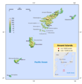
| 07:04, 24 April 2007 |  | 1,500 × 1,540 (393 KB) | Bamse | {{Information |Description=Topographic map of the w:Amami Islands (German version) |Source=own work |Date=24-04-2007 |Author=me, (~~~) |other_versions=Image:Amami_Islands-en.png }} {{Kartenwerkstatt}} {{GFDL-GMT}} | |
| 06:37, 20 April 2007 |  | 1,500 × 1,540 (392 KB) | Bamse | {{Information |Description=Topographic map of the Amami Islands, Japan (German version) |Source=own work |Date=20-04-2007 |Author=me, (~~~) |Permission= |other_versions= }} {{Kartenwerkstatt}} {{GFDL-GMT}} | |
| 01:14, 16 April 2007 |  | 1,500 × 1,540 (379 KB) | Bamse | {{Information |Description=Topographic map of the Amami Islands, Japan. (German version) |Source=self-made |Date=16-03-2007 |Author=me, Bamse |Permission= |other_versions= }} {{GFDL-GMT}} | |
| 00:01, 16 April 2007 |  | 1,500 × 1,540 (368 KB) | Bamse | {{Information |Description=Topographic map of the Amami Islands, Japan. (German version) |Source=self-made |Date=16-04-2007 |Author=me, Bamse |Permission= |other_versions= }} {{GFDL-GMT}} | |
| 07:11, 13 April 2007 |  | 2,500 × 2,566 (857 KB) | Bamse | {{Information |Description=Topographic map of the Amami Islands, Japan. (German version) |Source=self-made |Date=13-04-2007 |Author= me, ~~~ |other_versions= }} {{GFDL-GMT}} |
File usage
There are no pages that use this file.
Global file usage
The following other wikis use this file:
- Usage on az.wikipedia.org
- Usage on de.wikipedia.org
- Usage on ru.wikipedia.org


 Français
 Italiano


