
 Français
 Italiano
Size of this PNG preview of this SVG file: 757 × 378 pixels. Other resolutions: 320 × 160 pixels | 640 × 320 pixels | 1,024 × 511 pixels | 1,280 × 639 pixels | 2,560 × 1,278 pixels.
Original file (SVG file, nominally 757 × 378 pixels, file size: 67 KB)
This is a file from the Wikimedia Commons and may be used by other projects. Information from its description page there is shown below. Commons is a freely licensed media file repository. |
.svg)
Summary
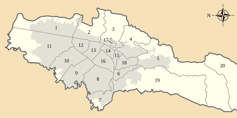
| Description | Español: Localidades del Distrito Capital, Colombia. 1 - Usaquén, 2 - Chapinero, 3 - Santafé, 4- San Cristóbal, 5 - Usme, 6 - Tunjuelito, 7 - Bosa, 8 - Kennedy, 9 - Fontibón, 10 - Engativá, 11 - Suba, 12 - Barrios Unidos, 13 - Teusaquillo, 14 - Los Mártires, 15 - Antonio Nariño, 16 - Puente Aranda, 17 - La Candelaria, 18 - Rafael Uribe, 19 - Ciudad Bolívar, 20 - Sumapaz English: Localities of Capital District, Colombia. 1 - Usaquén, 2 - Chapinero, 3 - Santafé, 4- San Cristóbal, 5 - Usme, 6 - Tunjuelito, 7 - Bosa, 8 - Kennedy, 9 - Fontibón, 10 - Engativá, 11 - Suba, 12 - Barrios Unidos, 13 - Teusaquillo, 14 - Los Mártires, 15 - Antonio Nariño, 16 - Puente Aranda, 17 - La Candelaria, 18 - Rafael Uribe, 19 - Ciudad Bolívar, 20 - Sumapaz |
| Date | |
| Source | Own work |
| Author | Milenioscuro |
Licensing
I, the copyright holder of this work, hereby publish it under the following license:
This file is licensed under the Creative Commons Attribution-Share Alike 3.0 Unported license.
- You are free:
- to share – to copy, distribute and transmit the work
- to remix – to adapt the work
- Under the following conditions:
- attribution – You must give appropriate credit, provide a link to the license, and indicate if changes were made. You may do so in any reasonable manner, but not in any way that suggests the licensor endorses you or your use.
- share alike – If you remix, transform, or build upon the material, you must distribute your contributions under the same or compatible license as the original.
File history
Click on a date/time to view the file as it appeared at that time.
| Date/Time | Thumbnail | Dimensions | User | Comment | |
|---|---|---|---|---|---|
| current | 11:45, 17 November 2013 | | 757 × 378 (67 KB) | Milenioscuro | User created page with UploadWizard |
File usage
There are no pages that use this file.
Global file usage
The following other wikis use this file:
- Usage on de.wikipedia.org
- Usage on en.wikipedia.org
- Bogotá
- Engativá
- Bogotá River
- Fontibón
- Plaza de Bolívar, Bogotá
- El Burro
- Barrios Unidos
- Antonio Nariño, Bogotá
- Chapinero
- Kennedy, Bogotá
- Sumapaz
- Los Mártires
- Teusaquillo
- Guadalupe Hill
- Usaquén
- La Candelaria, Bogotá
- Template:Bogotá
- San Cristóbal, Bogotá
- Metropolitan Area of Bogotá
- Santa Fe, Bogotá
- Usme
- Tunjuelito
- Bosa, Bogotá
- Suba, Bogotá
- Puente Aranda
- Rafael Uribe Uribe, Bogotá
- Ciudad Bolívar, Bogotá
- Bogotá savanna
- Monserrate
- Bacatá
- 93 Park
- Urban water management in Bogotá
- Ciudad Tunal
- Techo, Bogotá
- Wikipedia:WikiProject Cities/Capital city templates
- Timeline of Bogotá
- BD Bacatá
- Wetlands of Bogotá
- Capellanía (wetland)
- Córdoba (wetland)
- Jaboque
- La Vaca
- Techo (wetland)
- La Conejera
- Santa María del Lago
- Tibabuyes
- List of Muisca toponyms
- Eastern Hills (Bogotá)
- Thomas van der Hammen Natural Reserve
View more global usage of this file.
.svg)
Metadata
.svg)
Explore the world

United states
New York

Japan
Tokyo

Singapore
Singapore
