
 Français
 Italiano
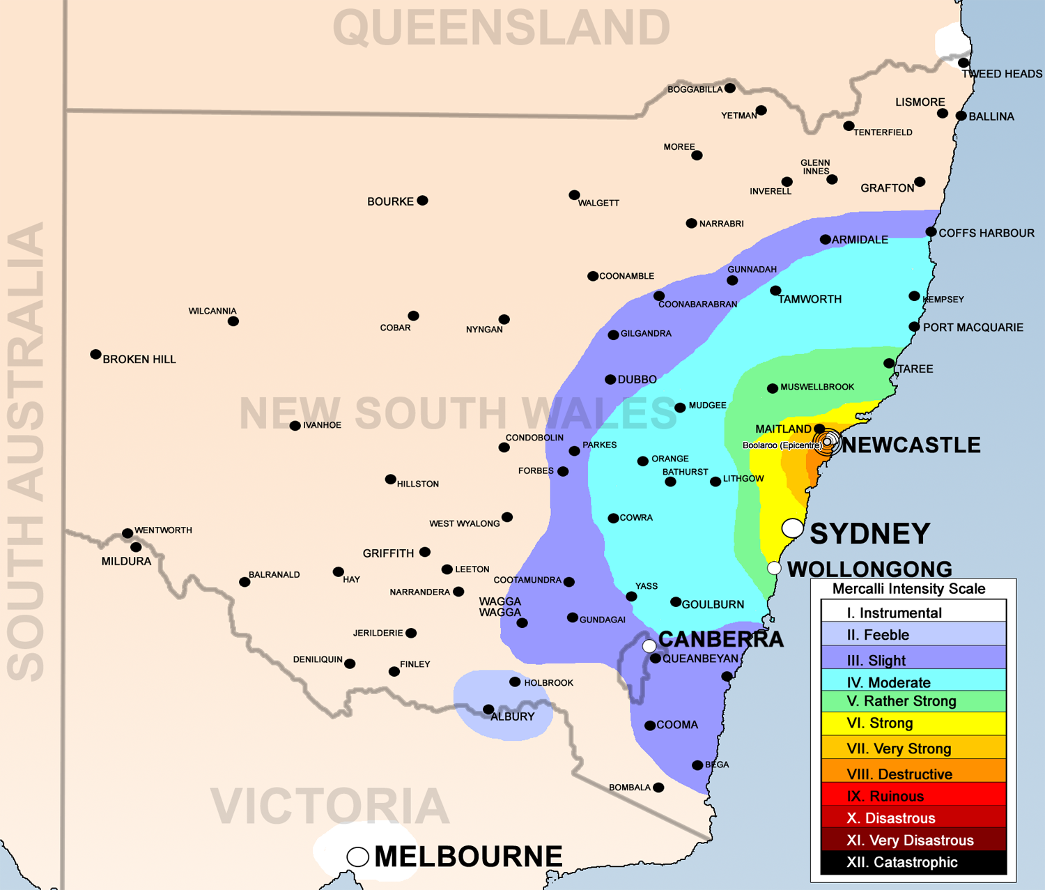
Size of this preview: 704 × 599 pixels. Other resolutions: 282 × 240 pixels | 564 × 480 pixels | 902 × 768 pixels | 1,203 × 1,024 pixels | 1,500 × 1,277 pixels.
Original file (1,500 × 1,277 pixels, file size: 1.07 MB, MIME type: image/png)
This is a file from the Wikimedia Commons and may be used by other projects. Information from its description page there is shown below. Commons is a freely licensed media file repository. |
Summary
| Description | English: 1989 Newcastle earthquake map base on [1], [2], [3], [4] using the Mercalli intensity scale |
| Date | |
| Source | Data based on Geoscience Australia [5] and Own work by uploader |
| Author | Bidgee |
Licensing
I, the copyright holder of this work, hereby publish it under the following license:
This file is licensed under the Creative Commons Attribution 3.0 Unported license.
- You are free:
- to share – to copy, distribute and transmit the work
- to remix – to adapt the work
- Under the following conditions:
- attribution – You must give appropriate credit, provide a link to the license, and indicate if changes were made. You may do so in any reasonable manner, but not in any way that suggests the licensor endorses you or your use.
File history
Click on a date/time to view the file as it appeared at that time.
| Date/Time | Thumbnail | Dimensions | User | Comment | |
|---|---|---|---|---|---|
| current | 08:49, 1 June 2008 | | 1,500 × 1,277 (1.07 MB) | Bidgee | {{Information |Description={{en|1=1989 Newcastle earthquake map base on [http://www.ema.gov.au/agd/EMA/emaSchools.nsf/Page/Lesson_Plans_Student_Worksheet_Student_Worksheet_-_Earthquakes], [http://www.ncc.nsw.gov.au/discover_newcastle/local_history/newcast |
File usage
The following page uses this file:
Global file usage
The following other wikis use this file:
- Usage on bn.wikivoyage.org
- Usage on en.wikipedia.org
- Usage on es.wikipedia.org
- Usage on fr.wikipedia.org
- Usage on he.wikipedia.org
- Usage on it.wikivoyage.org
- Usage on ja.wikipedia.org
- Usage on ko.wikipedia.org
- Usage on pl.wikipedia.org
- Usage on www.wikidata.org
- Usage on zh.wikivoyage.org
Metadata
Explore the world

United states
New York

Japan
Tokyo

Singapore
Singapore
