
 Français
 Italiano
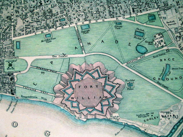
No higher resolution available.
1844_Map_of_Fort_William_and_Esplanade.jpg (640 × 480 pixels, file size: 150 KB, MIME type: image/jpeg)
This is a file from the Wikimedia Commons and may be used by other projects. Information from its description page there is shown below. Commons is a freely licensed media file repository. |
Summary
| Description | Fort William in its context, in an SDUK ("Society for the Diffusion of Useful Knowledge") map from 1844 | |||||||||
| Date | ||||||||||
| Source | www.columbia.edu | |||||||||
| Creator | Society for the Diffusion of Useful Knowledge | |||||||||
| Geotemporal data | ||||||||||
| Bounding box |
| |||||||||
| Georeferencing | ||||||||||
Licensing
| This work is in the public domain in its country of origin and other countries and areas where the copyright term is the author's life plus 70 years or fewer. | |
| This file has been identified as being free of known restrictions under copyright law, including all related and neighboring rights. | |
File history
Click on a date/time to view the file as it appeared at that time.
| Date/Time | Thumbnail | Dimensions | User | Comment | |
|---|---|---|---|---|---|
| current | 18:14, 9 February 2011 | | 640 × 480 (150 KB) | Quibik | Color balance and contrast. |
| 09:01, 5 February 2010 |  | 640 × 480 (115 KB) | Jayantanth | == Summary == {{Information |Description=Fort William in its context, in an SDUK ("Society for the Diffusion of Useful Knowledge") map from 1844 |Source=http://www.columbia.edu/itc/mealac/pritchett/00routesdata/1600_1699/calcutta/fortwilliam/fortwilliam.h |
File usage
There are no pages that use this file.
Global file usage
The following other wikis use this file:
- Usage on ar.wikipedia.org
- Usage on bn.wikipedia.org
- Usage on en.wikipedia.org
- Usage on es.wikipedia.org
- Usage on fr.wikipedia.org
- Usage on ja.wikipedia.org
- Usage on kn.wikipedia.org
- Usage on ml.wikipedia.org
- Usage on no.wikipedia.org
- Usage on sat.wikipedia.org
- Usage on ta.wikipedia.org
- Usage on zh.wikipedia.org
Metadata
Explore the world

United states
New York

Japan
Tokyo

Singapore
Singapore
