Ashburham
Ashburnham is a town in Massachusetts.
Understand
[edit]History
[edit]European settlement of Ashburnham began in 1736, and it was incorporated as a town in 1765. The lands that make up the town had been granted to officers and soldiers of a 1690 expedition to Canada. It had been called the Plantation of Dorchester-Canada until it was incorporated.
Get in
[edit]
State Routes 101, 12, and 140
Get around
[edit]See
[edit]Do
[edit]
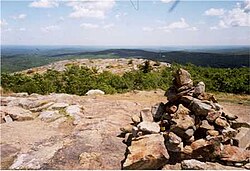
- 1 Mount Watatic. at 1,831 ft, is the second highest mountain in Massachusetts east of the Berkshires. Trailhead is off of MA 119.
- 2 Wapack Trail. The Wapack Trail is one of the oldest public, interstate hiking trails in the United States. Opened in 1923, it follows the Wapack Range for 21 miles (34 km), between Mount Watatic in Ashburnham, Massachusetts and North Pack Monadnock mountain in Greenfield, New Hampshire
Buy
[edit]Eat
[edit]- 1 Yaka Sawa Sushi and Grill, ☏ +1 978-252-5679. Sushi bar that offers other Asian dishes as well
Drink
[edit]- Tavern On Central, 3 Central St, Ashburnham, ☏ +1 978-827-1272. Tavern that offers a large selection of draft & bottle Beer as well as pub & American comfort foods
Sleep
[edit]Connect
[edit]Go next
[edit]| Routes through Ashburnham |
| Gardner ← | S | → Jct |
| Brattleboro | W | → Ashby → Townsend |


 Français
 Italiano


