
 Français
 Italiano
Größe der PNG-Vorschau dieser SVG-Datei: 494 × 600 Pixel. Weitere Auflösungen: 198 × 240 Pixel | 395 × 480 Pixel | 633 × 768 Pixel | 843 × 1.024 Pixel | 1.687 × 2.048 Pixel | 1.108 × 1.345 Pixel.
Originaldatei (SVG-Datei, Basisgröße: 1.108 × 1.345 Pixel, Dateigröße: 302 KB)
Beschreibung
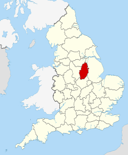
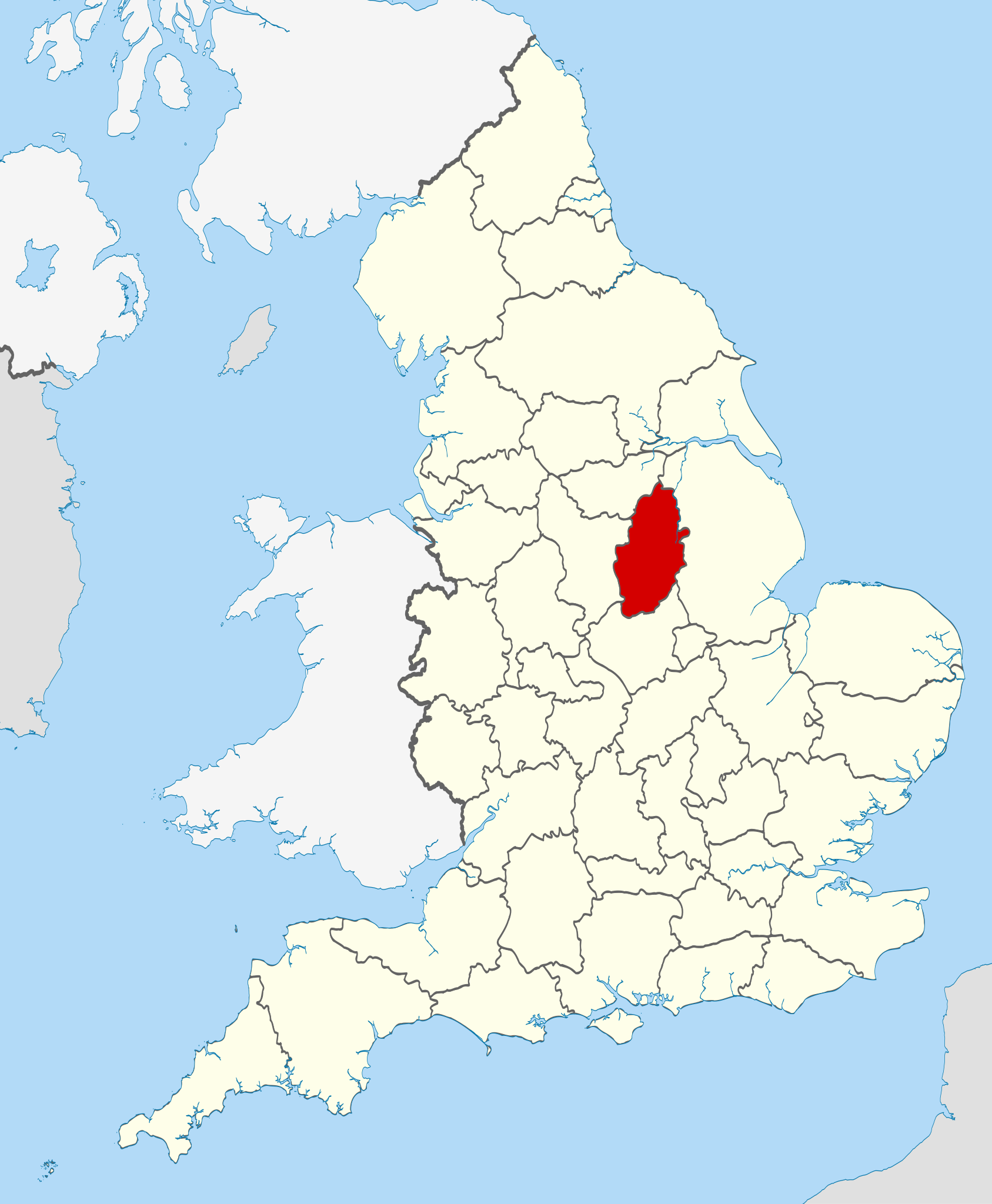
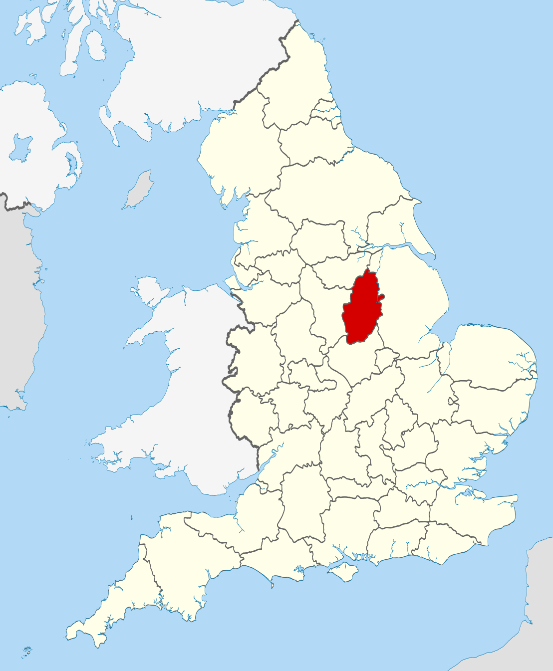
| Beschreibung | Location of the ceremonial county of Nottinghamshire within England. |
| Datum | |
| Quelle |
National Geospatial-Intelligence Agency
|
| Urheber | Nilfanion |
Lizenz
Ich, der Urheberrechtsinhaber dieses Werkes, veröffentliche es hiermit unter der folgenden Lizenz:
Diese Datei ist unter der Creative-Commons-Lizenz „Namensnennung – Weitergabe unter gleichen Bedingungen 3.0 nicht portiert“ lizenziert.
- Dieses Werk darf von dir
- verbreitet werden – vervielfältigt, verbreitet und öffentlich zugänglich gemacht werden
- neu zusammengestellt werden – abgewandelt und bearbeitet werden
- Zu den folgenden Bedingungen:
- Namensnennung – Du musst angemessene Urheber- und Rechteangaben machen, einen Link zur Lizenz beifügen und angeben, ob Änderungen vorgenommen wurden. Diese Angaben dürfen in jeder angemessenen Art und Weise gemacht werden, allerdings nicht so, dass der Eindruck entsteht, der Lizenzgeber unterstütze gerade dich oder deine Nutzung besonders.
- Weitergabe unter gleichen Bedingungen – Wenn du das Material wiedermischst, transformierst oder darauf aufbaust, musst du deine Beiträge unter der gleichen oder einer kompatiblen Lizenz wie das Original verbreiten.
 | Es ist erlaubt, die Datei unter den Bedingungen der GNU-Lizenz für freie Dokumentation, Version 1.2 oder einer späteren Version, veröffentlicht von der Free Software Foundation, zu kopieren, zu verbreiten und/oder zu modifizieren; es gibt keine unveränderlichen Abschnitte, keinen vorderen und keinen hinteren Umschlagtext. Der vollständige Text der Lizenz ist im Kapitel GNU-Lizenz für freie Dokumentation verfügbar. |
Du darfst es unter einer der obigen Lizenzen deiner Wahl verwenden.
 | Dies ist eines der Bilder, die Teil der Serie wertvoller Bilder sind: Locator maps of the Ceremonial counties of England auf Wikimedia Commons. Die Bilderserie wurde anhand der Kriterien für wertvolle Bilder bewertet und gilt als die wertvollste Bildreihe auf Commons innerhalb des Geltungsbereichs: Locator maps of the Ceremonial counties of England Du kannst die Nominierung auf Commons:Valued image candidates/Locator maps of English ceremonial counties einsehen. |
Dateiversionen
Klicke auf einen Zeitpunkt, um diese Version zu laden.
| Version vom | Vorschaubild | Maße | Benutzer | Kommentar | |
|---|---|---|---|---|---|
| aktuell | 00:42, 24. Nov. 2010 | | 1.108 × 1.345 (302 KB) | Nilfanion | == Summary == {{Information |Description=Location of the ceremonial county of Nottinghamshire within England. |Source=Ordnance Survey [https://www.ordnancesurvey.co.uk/opendatadownload/products.html OpenData]: * |
Dateiverwendung
Die folgende Seite verwendet diese Datei:
Globale Dateiverwendung
Die nachfolgenden anderen Wikis verwenden diese Datei:
- Verwendung auf af.wikipedia.org
- Verwendung auf ar.wikipedia.org
- Verwendung auf arz.wikipedia.org
- Verwendung auf ast.wikipedia.org
- Verwendung auf be-tarask.wikipedia.org
- Verwendung auf be.wikipedia.org
- Verwendung auf bg.wikipedia.org
- Verwendung auf br.wikipedia.org
- Verwendung auf bs.wikipedia.org
- Verwendung auf ca.wikipedia.org
- Verwendung auf ceb.wikipedia.org
- Verwendung auf cs.wikipedia.org
- Verwendung auf dag.wikipedia.org
- Verwendung auf da.wikipedia.org
- Verwendung auf de.wikipedia.org
- Verwendung auf en.wikipedia.org
- Nottinghamshire
- University Farm (Nottinghamshire)
- Bircotes
- Manton, Nottinghamshire
- Soar Valley
- Redhill, Nottinghamshire
- Spion Kop, Nottinghamshire
- Bunny, Nottinghamshire
- North Leverton with Habblesthorpe
- Parliamentary constituencies in Nottinghamshire
- Adbolton
- Barton in Fabis
- Trent Lock
- Template:Nottinghamshire-geo-stub
- Wilford Hill
- Rhodesia, Nottinghamshire
- Meering
- Annesley
- Askham, Nottinghamshire
- Awsworth
- Barnby in the Willows
- Bathley
- Beckingham, Nottinghamshire
- Bestwood St. Albans
- Bevercotes
- Kneeton
- Beeston and Stapleford Urban District
- Bothamsall
- Bulcote
- Worksop Rural District
- Butler's Hill
- Westville, Nottinghamshire
Weitere globale Verwendungen dieser Datei anschauen.
Explore the world

United states
New York

Japan
Tokyo

Singapore
Singapore
