
 Français
 Italiano
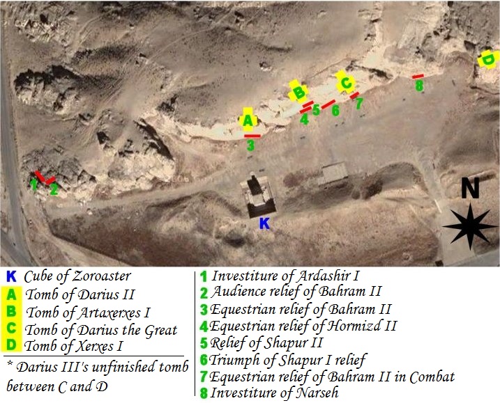
Es ist keine höhere Auflösung vorhanden.
Map_of_Naqsh-e_Rostam.jpg (717 × 579 Pixel, Dateigröße: 179 KB, MIME-Typ: image/jpeg)
Beschreibung
| Beschreibung | map of archeological site of Naqsh-e Rostam (Iran, fars Province, city of Marvdasht) |
| Datum | |
| Quelle | Own work using NASA's satellite picture of the place and an artifact sheme according to belgium archeologist Louis Vanden Berghe. |
| Urheber | Pentocelo |
| Andere Versionen | with french legends Image:Map of Naqsh-e Rostam (fr).jpg |
.jpg)
Lizenz
| Ich, der Urheberrechtsinhaber dieses Werkes, veröffentliche es als gemeinfrei. Dies gilt weltweit. In manchen Staaten könnte dies rechtlich nicht möglich sein. Sofern dies der Fall ist: Ich gewähre jedem das bedingungslose Recht, dieses Werk für jedweden Zweck zu nutzen, es sei denn, Bedingungen sind gesetzlich erforderlich. |
Dateiversionen
Klicke auf einen Zeitpunkt, um diese Version zu laden.
| Version vom | Vorschaubild | Maße | Benutzer | Kommentar | |
|---|---|---|---|---|---|
| aktuell | 06:56, 27. Feb. 2011 | | 717 × 579 (179 KB) | Dr. Persi | I took this file from the original work done by the User Pentocelo. This is his original work and therefore the credit belongs to him. He however uploaded the file as no copyright, enabling me to improve his original version. He has created two versions o |
| 21:58, 6. Feb. 2008 |  | 717 × 579 (75 KB) | Pentocelo~commonswiki | == Description == {{Information |Description= map of archeological site of Naqsh-e Rostam (Iran, fars Province, city of Marvdasht) |Source= Own work using NASA's satellite picture of the place and an artifact sheme according to belgium archeologist Louis | |
| 21:26, 6. Feb. 2008 |  | 721 × 624 (83 KB) | Pentocelo~commonswiki | {{Information |Description= map of archeological site of Naqsh-e Rostam (Iran, fars Province, city of Marvdasht) |Source= Own work using NASA's satellite picture of the place and an artifact sheme according to belgium archeologist Louis Vanden Berghe. |Da |
Dateiverwendung
Die folgende Seite verwendet diese Datei:
Globale Dateiverwendung
Die nachfolgenden anderen Wikis verwenden diese Datei:
- Verwendung auf ca.wikipedia.org
- Verwendung auf en.wikipedia.org
- Verwendung auf es.wikipedia.org
- Verwendung auf it.wikipedia.org
- Verwendung auf sl.wikipedia.org
- Verwendung auf vi.wikipedia.org
Metadaten
Explore the world

United states
New York

Japan
Tokyo

Singapore
Singapore
