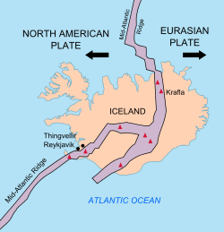
Iceland_Mid-Atlantic_Ridge_Fig16.gif (376 × 390 Pixel, Dateigröße: 9 KB, MIME-Typ: image/gif)
Dateiversionen
Klicke auf einen Zeitpunkt, um diese Version zu laden.
| Version vom | Vorschaubild | Maße | Benutzer | Kommentar | |
|---|---|---|---|---|---|
| aktuell | 01:02, 10. Mär. 2005 |  | 376 × 390 (9 KB) | Svart~commonswiki | Map showing the Mid-Atlantic Ridge splitting Iceland and separating the North American and Eurasian Plates. The map also shows Reykjavik, the capital of Iceland, the Thingvellir area, and the locations of some of Iceland's active volcanoes (red triangles) |
Dateiverwendung
Die folgende Seite verwendet diese Datei:
Globale Dateiverwendung
Die nachfolgenden anderen Wikis verwenden diese Datei:
- Verwendung auf ar.wikipedia.org
- Verwendung auf ast.wikipedia.org
- Verwendung auf azb.wikipedia.org
- Verwendung auf bg.wikipedia.org
- Verwendung auf bn.wikipedia.org
- Verwendung auf bn.wikivoyage.org
- Verwendung auf cs.wikipedia.org
- Verwendung auf de.wikipedia.org
- Verwendung auf dz.wikipedia.org
- Verwendung auf en.wikipedia.org
- Verwendung auf eo.wikipedia.org
- Verwendung auf es.wikipedia.org
- Verwendung auf fa.wikipedia.org
- Verwendung auf fiu-vro.wikipedia.org
- Verwendung auf fi.wikipedia.org
- Verwendung auf hr.wikipedia.org
- Verwendung auf hu.wikipedia.org
- Verwendung auf is.wikipedia.org
- Verwendung auf is.wikibooks.org
- Verwendung auf it.wikipedia.org
- Verwendung auf ja.wikipedia.org
- Verwendung auf ms.wikipedia.org
- Verwendung auf nds.wikipedia.org
- Verwendung auf nn.wikipedia.org
- Verwendung auf no.wikipedia.org
- Verwendung auf pl.wikipedia.org
- Verwendung auf pt.wikipedia.org
- Verwendung auf rm.wikipedia.org
- Verwendung auf ro.wikipedia.org
Weitere globale Verwendungen dieser Datei anschauen.


 Français
 Italiano


